The rainy season in Madagascar is usually between November and April, while between May and October, there is drought. During the northern hemispheric winter, from October to April, and it rains frequently. The typical Malagasy climate and the shift in rainfall rates during the rainy season can be well seen in our climate diagrams, as shown in the screenshot.
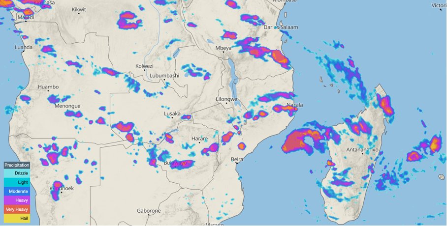


On our weather radar, you can observe heavy rainfalls in Madagascar precisely. The different colours indicate the intensities of the precipitation ranging from turquoise for drizzles to red for heavy precipitation sums. The sample screenshot shows a typical radar image for Madagascar with many small heavy precipitation cells.
Dense rain clouds are also clearly visible on our satellite map.
Warm temperatures and rainfall dominate the southern hemispheric summer months in Madagascar. While the east coast is constantly exposed to the southeast trade winds, their humidity and thus all-year-round rain, the northwest coast of Madagascar, in particular, is affected by the northwest monsoon between November and April.

The monsoon is a large-scale, seasonal air circulation event mainly caused by the displacement of the intra-tropical convergence zone (ITC). The ITC is a low-pressure trough that forms over the equator due to steep solar irradiation angles and the consequent rise of strongly warmed air. The trade winds from the north and south flow towards the ITC. The rise of warm air causes cloud formation and heavy precipitation.
Besides the slight tilt of the earth's axis and the resulting seasonal shift of the sun's highest zenith angle between the north and south tropics, the distribution of land and ocean masses and their thermal characteristics also causes a shift in the ITC. While the highest zenith at times of the northern hemispheric winter is south of the equator, air masses of the northeast trade wind flow towards the ITC and are deflected to the left. This creates the so-called northwest monsoon wind, which receives much moisture on its way to the ITC. This results in large precipitation amounts, which is experienced in Madagascar, particularly on the northwest coast. In addition, tropical cyclones can form now and then during the warm months in the southwestern part of the Indian Ocean. They have already caused significant devastation in Madagascar occasionally.

Our weather maps are designed to detect local conditions and track the current weather. On our weather radar, you can follow the recent precipitation event in Madagascar, showing the course of the rainfalls in the highest resolution. In addition, you can consult our clouds & precipitation maps to access precipitation forecasts for the next few days.
It is also helpful to check our wind animation to observe the winds that usually accompany Madagascar's heavy rains.
In addition, our historical radar and satellite data reach back to 2020 with our point+ subscription and, therefore, allow you to analyse precipitation patterns for Madagascar over the last years. You can test point+ for 14 days and experience it yourself!
With point+, you can activate the radar overlay on the satellite map and select your desired period in the past by clicking on the calendar icon in the bottom right-hand corner of the navigation bar.
