Predictability in 14-day forecast:
The predictability is the estimated certainty of our weather forecast. It considers uncertainties in pressure, precipitation, temperature, wind, as well as larger scale patterns and climate inconsistencies, and is a unique offer developed by meteoblue. Forecasts achieve a high and constant predictability in high pressure areas and locations with low weather variance (like deserts). Predictability is lower in low pressure situations, with intense precipitation events or thunderstorms. Our goal is to show that some weather events are not so easy to predict and that some forecasts might yet be inaccurate or may change distinctly within the next 12 hours.
More information about predictability can be found on our help pages.
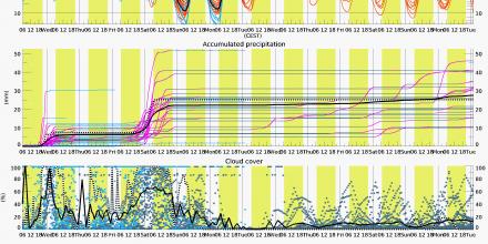
We have made considerable effort to compile different forecasts of different models into one diagram, showing in more detail which weather element is uncertain at a given time.
The
multimodel - ensemble is made from many completely different forecast models, showing "different opinions", whereas a normal ensemble forecast is generated by the same model computing different forecast based on slightly different initial weather conditions (showing "variations of the same opinion").
The multimodel ensemble forecast includes information on
temperature, accumulated precipitation, cloud cover as well as wind direction and wind speed.
For the first few days, we included the high resolution models shown in the multimodel diagram, because normal ensemble systems do heavily underestimate the uncertainties in the first few days. The red lines are the “true ensemble members" and per definition all carry the same likelyhood of materialising. In contrast, the multimodel members (blue lines) come from different forecast models, so some members are likely better than others for a specific region.
Precipitation amounts are accumulated over time, for easier reading of the different forecasts and total amounts for the next 14 days. The wind direction is shown in form of a daily wind rose diagram, where larger segments indicate that this direction is more frequent and more likely than smaller segments.
Note that in general, forecasts become less accurate, the longer they reach into the future. However, in practice, a 4-day forecast can be more accurate than a 2-day forecast if e.g. there is a cold front passing on day 2. So, it is important to always consider the predictability in your planning.


