Mountains do not simply "sit under" the atmosphere. They redirect it, lift it, block it and disturb it, often across a wide range of scales. Elevated terrain covers about a third of the Earth's land surface and has a major influence on local weather, regional patterns and airflow in both the lower and upper atmosphere.
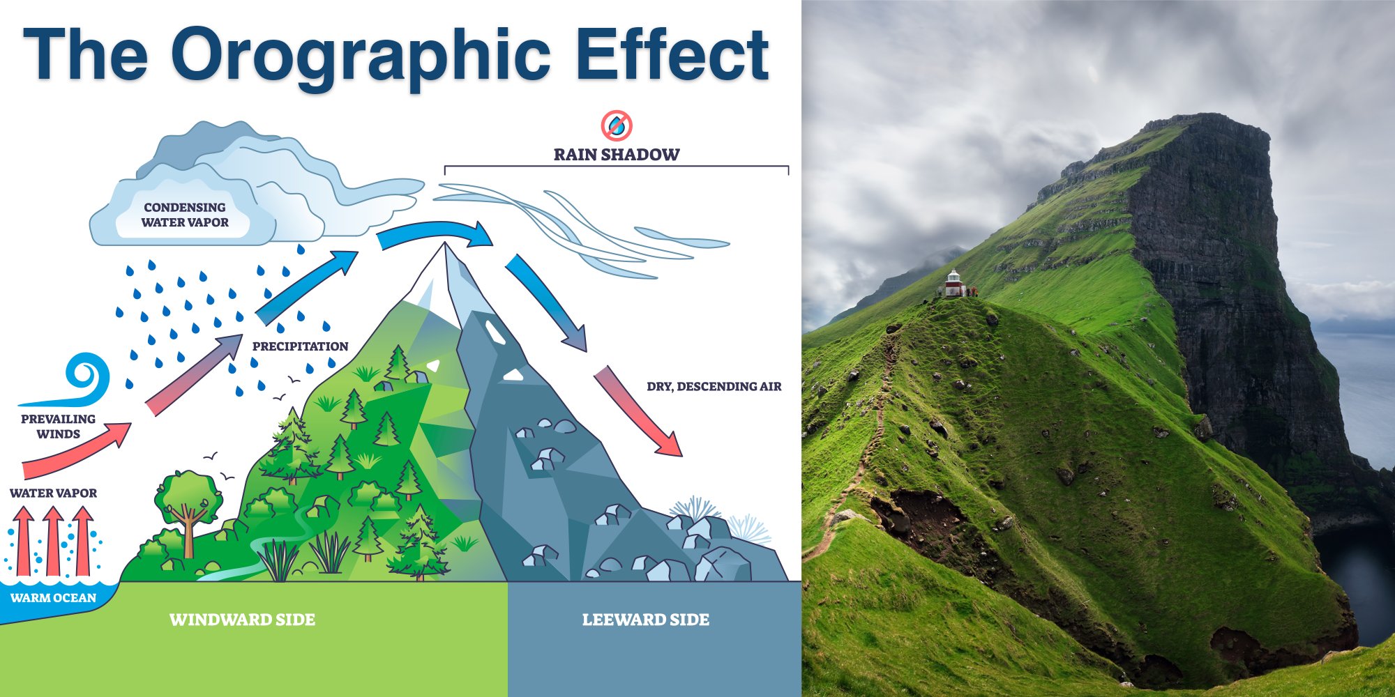
The most familiar orographic effect is the one many people already know from everyday geography: when moist air is forced to rise over higher ground, it cools, condenses and often produces clouds and precipitation. This is the classic orographic lift mechanism. It is why the windward side of a mountain range is often wetter, cloudier and greener than the leeward side. As the air descends on the far side, it warms and dries, creating a rain shadow. This basic pattern helps explain some of the world's major dry regions, from the Patagonia to parts of the western United States.
But the real story is more interesting than a simple "wet side, dry side" rule.
Terrain changes the path of air
When airflow meets terrain, it does not always just go over it. Sometimes it is lifted over the obstacle; sometimes it is slowed, split and diverted around it; and sometimes it is partly blocked, especially if the ridge is high and the air is stable. In mountainous weather research, these processes are central because they can alter storm tracks, trigger convergence zones and create sharp contrasts over short distances. Mountains also launch gravity waves into the atmosphere as air rises and sinks across the terrain. These waves can propagate downwind, affect cloud formation and create turbulence that matters for both forecasting and aviation.
In some situations, stronger barriers can do more than just distort the flow. Idealised modelling of lake-effect systems shows that a modest hill may slightly enhance precipitation through ascent and reduced sublimation, while a much higher ridge can actually block low-level flow strongly enough to shift the heaviest precipitation upstream rather than simply increasing it over the slope. In other words, bigger terrain does not always mean a stronger local precipitation maximum exactly where one might expect it.
Why precipitation often peaks in the "wrong" place
For average rainfall totals, mountains often increase precipitation because uplift squeezes more moisture out of the air. Yet for extreme precipitation, the picture can be more nuanced. A radar-based study of coastal and mountainous terrain found that the response depends strongly on timescale. Very short and hourly extremes were strongest near the coast, while longer-duration extremes peaked farther inland, around orographic barriers. Generally terrain does not influence all precipitation in the same way. Short-lived convective bursts may be favoured where convergence is strongest and instability is readily released. Longer-lasting events, by contrast, often benefit from the sustained lifting and moisture extraction that mountains provide. This is a useful reminder for weather interpretation. A mountain range can increase seasonal or event-total precipitation while not necessarily producing the highest hourly extremes at the highest elevations. For risk, that distinction matters. Short-duration hazards such as urban pluvial flooding may peak in one zone, while longer-duration hazards such as flash floods may be more relevant farther inland or upslope.
Wind: from gentle steering to violent acceleration
Terrain also shapes wind in ways that are immediately felt on the ground. Valleys can channel the flow into preferred directions. Mountain passes can funnel and accelerate winds, producing strong gusts in relatively narrow corridors. Some regions show highly distinctive wind roses for this reason. In Germany, for example, one recent study found that some cities were mainly shaped by the broader synoptic pattern, while others showed a strong orographic signature; Cologne, in particular, stood out for the influence of the Rhine valley on wind direction.
That channeling effect can be quite significant. It affects ventilation, pollutant transport and the local distribution of heat. The same study found that terrain-linked wind turning can differ markedly between locations, with some places showing well-defined turning centres or bands under particular flow directions. In practice, this means that local wind behaviour over complex terrain may differ substantially from what a single point observation or a coarse forecast field suggests.
For forecasters, the challenge is that wind over terrain is not just about direction. It is also about speed changes, turbulence and vertical motion. Mountain waves, downslope windstorms and flow separation can all develop when the larger-scale flow interacts with terrain in the right way. This is one reason why mountain regions remain a major source of forecast uncertainty and why dedicated field campaigns continue to focus on observations over complex terrain.
Temperature: cold pools, inversions and foehn-like warming
Temperature is also reshaped by topography. In valleys and basins, dense cold air can drain downslope at night and pool in low-lying areas. Under calm, stable conditions this produces temperature inversions, with colder air trapped below warmer air. These inversions can persist for days, especially in winter, and they favour fog, frost and the build-up of air pollution because vertical mixing is suppressed.
The opposite effect is also possible on the lee side of mountains. When air descends after losing moisture on the windward side, it warms by compression. This is the basis of foehn-type winds: dry, sometimes surprisingly mild air descending into leeward valleys. Even without a classic foehn event, terrain can create neighbouring areas with very different daytime temperatures depending on exposure, elevation and air drainage.
In cities surrounded by relief, these temperature effects become even more complex. Orography can alter the local wind field, which in turn affects urban ventilation and the distribution of heat. In other words, terrain does not just influence "mountain weather", it also shapes the climate of the valleys, plains and urban areas around it.
Local terrain, larger consequences
Although orographic effects are often most obvious locally, they do not stop there. Mountains can modify storm structure, influence monsoon behaviour, steer large-scale airflow and even interact with ocean-atmosphere patterns. The Himalayas, for example, help shield South Asia from colder continental air in winter and play a major role in organising the monsoon. Other ranges, such as the Rockies, can influence the jet stream and downstream weather extremes.
That wider importance is one reason why weather and climate models need to represent terrain well. Yet mountain regions remain difficult to observe and model. Airflow over complex terrain includes blocking, gravity waves, turbulent drag, cold-pool formation and local wind systems that can be missed or smoothed out at low resolution. This is why mountain meteorology remains such an active research field, and why better observations are essential for better forecasts.
Why this matters in practice
For users of weather information, terrain is often the difference between a general forecast and a useful one. A broad regional outlook might say "showers, light wind, mild", while the local reality could be heavy rain on one slope, dry conditions in the lee, strong gusts in a pass and frost in a valley bottom by dawn.
That is the essence of orographic weather: the atmosphere may be continuous, but the surface beneath it is not. Hills and mountains turn large-scale weather into local weather. They decide where uplift begins, where clouds deepen, where the air dries out, where cold settles and where wind becomes hazardous. Understanding those effects is essential not only for mountain forecasts, but for aviation, hydrology, agriculture, transport, urban planning and climate risk assessment.
Have you ever observed a striking weather phenomenon shaped by terrain, whether in your local surroundings or while travelling? From clouds clinging to windward slopes to sudden gusts funnelling through valleys, these moments often leave a lasting impression. Share your experience in the dedicated discussion on the meteoblue Community Forum and explore how orographic effects reveal themselves across different landscapes.
