
Weather models are the foundation of modern forecasting. They combine physics, mathematics, global observation networks and supercomputing to simulate how the atmosphere behaves and evolves. Over the past decades, they have transformed forecasting into one of the most computationally advanced fields in science.
What Is a Numerical Weather Prediction Model?
At its core, a weather model – formally known as a Numerical Weather Prediction (NWP) model – is a mathematical representation of the Earth's atmosphere. The atmosphere behaves like a fluid: it moves, rises, cools, condenses, interacts with land and oceans, and responds to solar radiation. These processes are governed by physical laws, including Newton's laws of motion, the conservation of mass and energy, and the principles of thermodynamics. Weather models translate these physical laws into equations that describe how air temperature, pressure, wind and moisture change over time.
Because these equations are highly complex and interconnected, they cannot be solved manually. Instead, they are processed by powerful supercomputers capable of performing billions to trillions of calculations per second. Every modern forecast you see is the result of these numerical computations.

From Observations to Initial Conditions
Forecasting begins with observations. Around the globe, measurements are taken continuously by surface weather stations, weather balloons, aircraft, ships, ocean buoys, radar systems and satellites. Satellites are particularly crucial because they provide near-global coverage, including over oceans and remote regions where ground-based stations are sparse. They measure radiation emitted and reflected by the Earth and atmosphere, allowing scientists to infer cloud properties, temperature profiles and moisture content.
Each day, vast amounts of observational data are collected worldwide. However, raw observations alone cannot produce a forecast. The data must first be combined into a coherent picture of the atmosphere through a process called data assimilation. This step merges current measurements with short-term previous forecasts to generate the most accurate possible three-dimensional estimate of the current atmospheric state. This representation, known as the initial condition, serves as the starting point for the model simulation.
The importance of accurate initial conditions cannot be overstated. The atmosphere is highly sensitive to small differences. Even minor uncertainties at the start can amplify over time. In fact, preparing the initial atmospheric state often requires more computational effort than running the forecast itself.
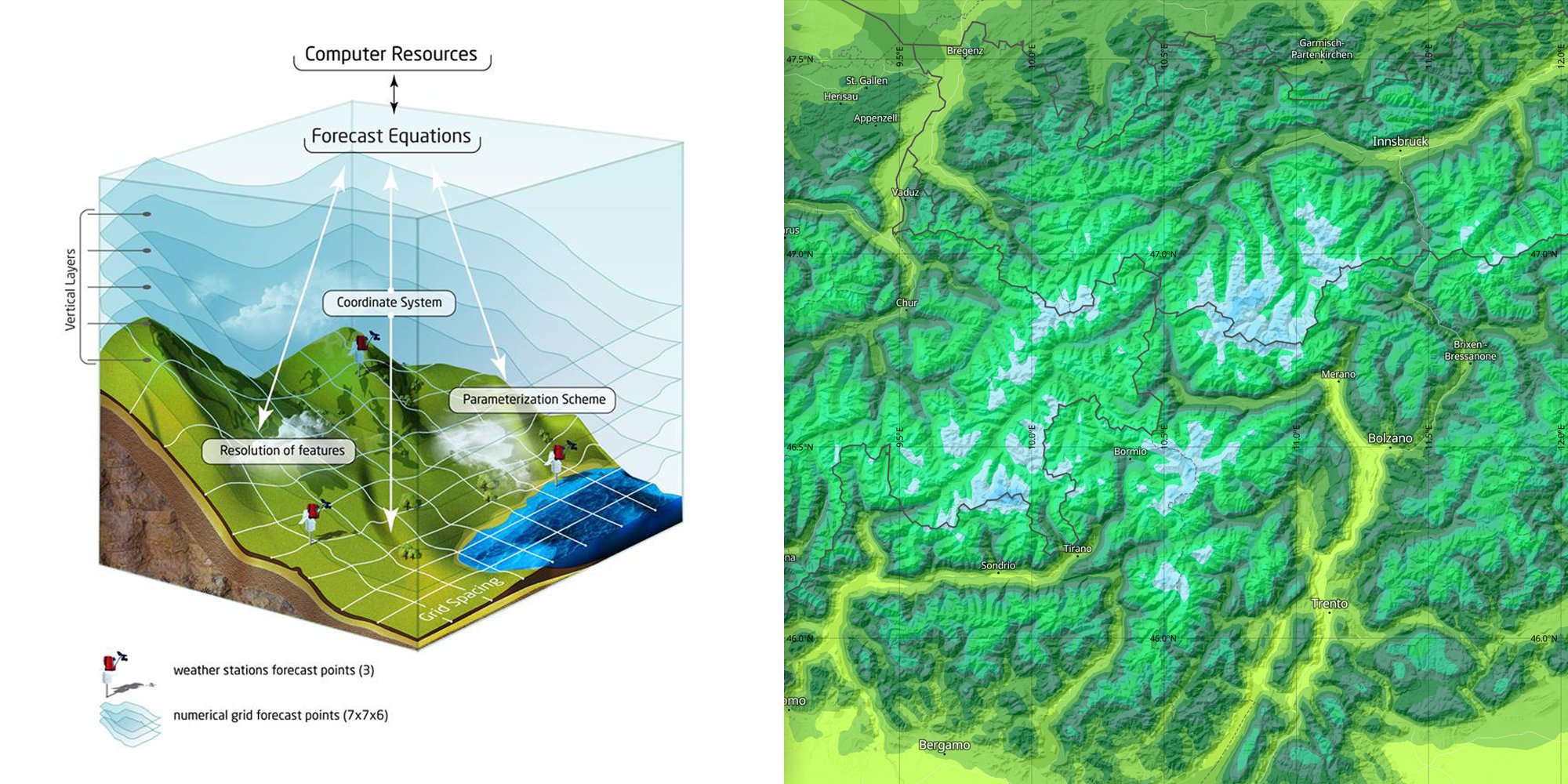
The Model Grid and Spatial Resolution
Once the initial state is defined, the atmosphere is divided into a three-dimensional grid. Imagine overlaying the Earth with a network of boxes that extend from the surface into the upper atmosphere. Each grid cell contains values such as temperature, pressure, wind speed, wind direction, humidity and cloud properties. The spacing between these grid points determines the model's spatial resolution.
Higher resolution means smaller grid boxes and more detailed representation of local features such as mountains, coastlines or urban areas. However, higher resolution also dramatically increases computational demand. Global models typically operate with grid spacing ranging from roughly 9 to 25 kilometres. Regional high-resolution models may reduce this spacing to a few kilometres or less, allowing finer representation of local weather processes.
Simulating the Atmosphere Step by Step
With the grid established, the model begins solving the physical equations forward in time. It calculates how the air moves between grid cells, how pressure systems evolve, how clouds form and dissipate, how precipitation develops, and how radiation from the Sun interacts with the Earth's surface and atmosphere. These calculations are repeated step by step, often simulating changes in increments of just a few minutes. Through millions of such steps, the model produces forecasts extending hours, days or even weeks ahead.
Parameterisation: Representing Small-Scale Processes
Not all atmospheric processes can be represented explicitly at the scale of the grid. Some phenomena, such as small-scale turbulence or individual thunderstorms, occur at scales smaller than the grid spacing. To account for these processes, models use what is known as parameterisation. This involves simplified mathematical descriptions that approximate the average effect of small-scale processes on the larger-scale atmosphere. Parameterisation is one of the most complex and challenging aspects of model development, and differences in these schemes partly explain why different models can produce slightly different forecasts.
The Role of the Earth's Surface
Weather models rely not only on atmospheric observations but also on detailed information about the Earth's surface. Topography, land use, vegetation type, soil moisture, sea surface temperature, snow cover and sea ice all influence how energy and moisture are exchanged between the surface and the atmosphere. Mountains can redirect airflow, oceans store and release heat, and urban areas modify local temperature patterns. Accurate surface representation is therefore essential for reliable forecasts.
A Brief History of Numerical Weather Prediction
The concept of numerical weather prediction dates back more than a century. In 1922, British scientist Lewis Fry Richardson attempted to compute a weather forecast manually using atmospheric equations. His calculations took weeks and were ultimately unsuccessful due to limited data and computational limitations. However, his work laid the theoretical foundation for modern forecasting. Practical numerical prediction became feasible only with the development of electronic computers in the mid-twentieth century. From that point onward, advances in computing power, global observation systems and atmospheric science have steadily improved forecast accuracy.
Today, a four-day forecast can be as accurate as a one-day forecast was several decades ago. This improvement reflects continuous investment in research, better observational coverage and increasingly powerful supercomputers.
Understanding Forecast Limits
Despite these advances, weather models are not perfect. The atmosphere is inherently chaotic. Small differences in the initial state can grow rapidly, leading to diverging outcomes over time. Observations are never complete, some physical processes must be approximated, and computational resources remain finite. As a result, forecast confidence gradually decreases with longer lead times. Predictions for one to three days ahead are typically highly reliable. Beyond five to seven days, uncertainty grows, and after ten to fourteen days, forecasts become increasingly probabilistic rather than deterministic.
These limitations are not failures of specific models but reflect the fundamental nature of the atmosphere itself.
Final Reflections
Weather models represent one of the greatest scientific achievements of the modern era. They integrate physics, global collaboration, advanced mathematics and cutting-edge computing into a system that continuously analyses and predicts the state of our planet's atmosphere. Every forecast we consult – whether for tomorrow's rain or next week's temperature trend – is the product of decades of scientific innovation and international cooperation.
In the second part of this article, we will explore different types of global and regional models, ensemble forecasting, probabilistic approaches, machine learning applications and how hybrid modelling systems are shaping the future of weather prediction.
Interested in discussing this topic further or asking questions? Visit the dedicated section on the meteoblue Community Forum. Our experts and community members will be happy to continue the conversation.
