These new tools estimate the likelihood of fire-conducive conditions by combining meteorological data with risk modelling. Instead of interpreting individual parameters such as temperature or wind separately, users receive a location-specific assessment of how likely it is that conditions may support wildfire development during the forecast period.
This approach adds an important layer to traditional weather information – especially in environments where fire risk is closely linked to atmospheric conditions.
Fire risk is defined by conditions, not ignition
Wildfires are often associated with ignition events, but ignition alone does not determine their impact. The critical factor is whether environmental conditions allow a fire to start easily, spread rapidly, and become difficult to control.
Temperature, relative humidity, wind, recent precipitation, and vegetation dryness interact continuously. These variables influence fuel moisture and fire behaviour, often in complex and region-specific ways. A short period of dry, warm weather combined with wind can significantly increase fire potential, even in areas not typically considered high-risk.
Because these factors evolve over time, assessing wildfire danger requires more than a snapshot of current conditions – it requires a forward-looking view.
A changing climate and shifting fire patterns
Fire is a natural component of many ecosystems, but recent years have shown clear changes in how and where fires occur.
Warmer conditions increase evaporation and reduce moisture in vegetation. At the same time, shifts in precipitation patterns can create alternating periods of growth and drying, increasing the amount of available fuel. In some regions, this leads to longer fire seasons and more frequent high-risk situations.
These changes are not uniform. Some areas may experience reduced fire activity due to land-use changes, while others see an increase in extreme fire behaviour. In high-latitude forests and parts of Europe, fire risk is becoming more closely linked to weather variability and extended dry periods.
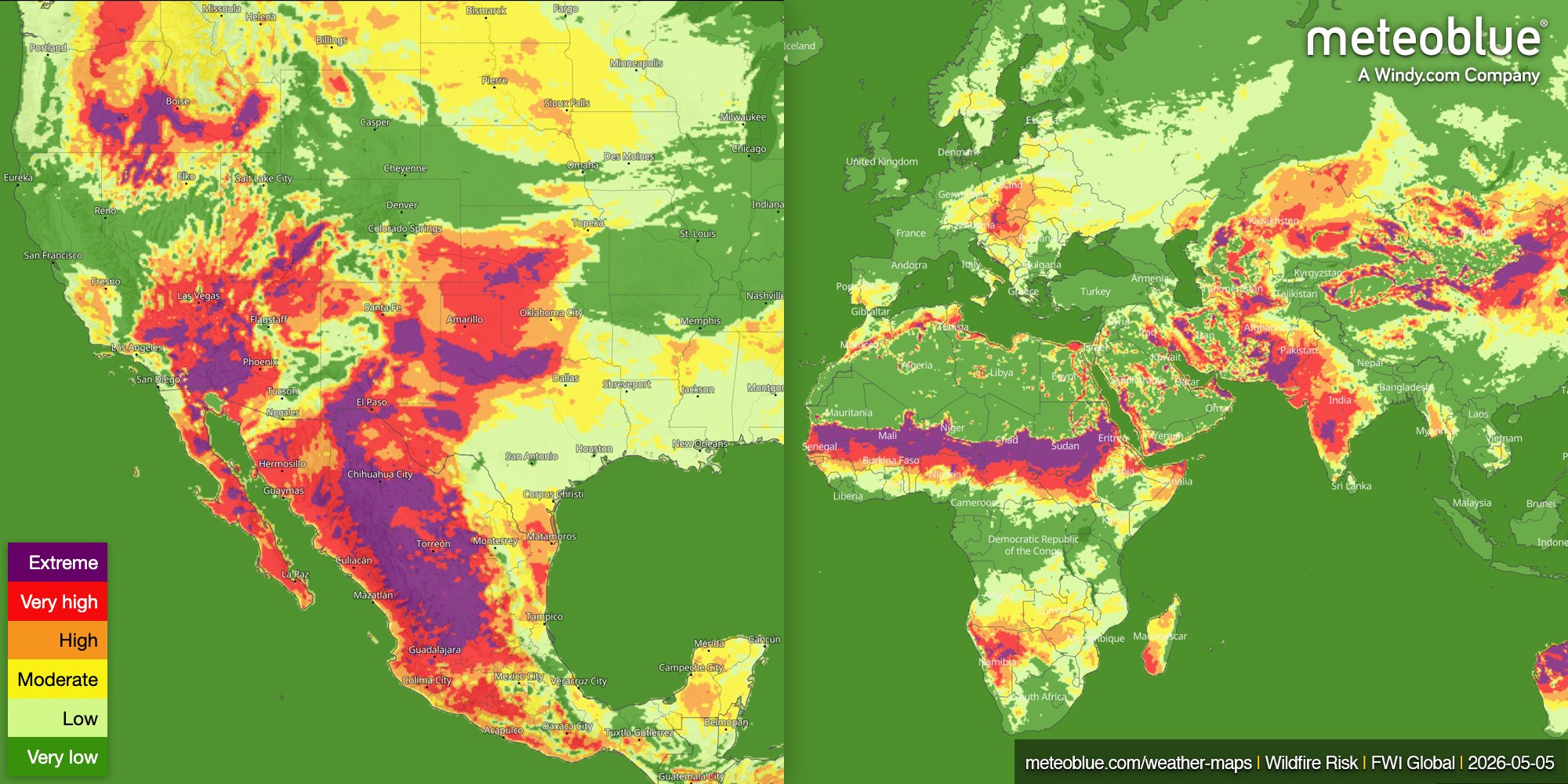
From weather data to wildfire risk mapping
The new meteoblue wildfire products interpret weather conditions as a clear risk signal.
The Wildfire Risk Maps visualise where conditions are favourable for wildfire development, based on a combination of atmospheric variables and surface conditions. The probabilistic wildfire variable in the Risk package quantifies this likelihood, providing a consistent metric that can be integrated into decision-making processes.
Rather than asking whether temperatures will be high or winds will be strong, the focus shifts to a more relevant question: how likely is it that these conditions together will create a hazardous situation? This type of information supports better situational awareness, particularly when multiple risk factors align.
Why a probabilistic approach is important
Weather forecasts describe expected conditions. Risk forecasts describe their potential impact. In wildfire applications, this distinction is critical.
High temperatures alone do not necessarily lead to fire risk unless combined with dry fuels and suitable wind conditions. By combining these factors into a probabilistic framework, wildfire risk becomes easier to interpret and compare across locations.
This approach also allows users to monitor how risk evolves over time, rather than reacting only when conditions have already become dangerous.
The role of large-scale weather patterns
Wildfire risk is often influenced by synoptic-scale conditions. High-pressure systems can lead to stable, dry, and warm weather, gradually reducing fuel moisture. In contrast, low-pressure systems may introduce cloud cover and precipitation, temporarily reducing fire risk but sometimes contributing to vegetation growth that later dries out.
Wind patterns are particularly important. Strong, dry winds can rapidly increase fire intensity and spread, while sudden shifts in wind direction can complicate fire behaviour.
Understanding these larger-scale patterns helps explain why wildfire risk can increase quickly, even in regions that were previously unaffected.
Supporting operational decisions
Wildfire risk information is most useful when it can be integrated into real workflows.
The new meteoblue wildfire risk data is available via API, customisable widgets, and the weather maps interface. This allows users to incorporate risk information directly into operational systems, whether for monitoring infrastructure, planning field operations, or assessing exposure.
For sectors such as energy, forestry, insurance, and civil protection, this provides a clearer basis for planning and response.
A step towards better preparedness
Wildfires cannot be prevented entirely, and ignition will always involve some level of uncertainty. What can be assessed and anticipated are the conditions that make fires more likely and more dangerous.
With weather data and probabilistic modelling, the new meteoblue wildfire risk products help monitor these conditions in advance, enabling earlier awareness, better decisions, and a clearer understanding of how weather can turn into real-world risk.
