A thunderstorm can transform local weather conditions in a matter of minutes. Their impacts are felt across aviation, transport, agriculture, and energy infrastructure, while severe cases may bring flash flooding, hail, destructive wind gusts, or even tornadoes. Although forecasting technology has advanced significantly, determining exactly when and where a thunderstorm will form remains highly complex. Looking at how thunderstorm cells develop and evolve helps explain why some storms remain weak and short-lived, while others organise into powerful and potentially destructive systems.
The Three Ingredients of a Thunderstorm
The formation of a thunderstorm requires several atmospheric ingredients to come together at the same time. The first is warm, moist air near the ground. During sunny days, solar radiation heats the surface, causing water to evaporate and the lower atmosphere to warm. Warm air is lighter than cold air, so it begins to rise. Moisture acts as the fuel for thunderstorm development, supplying the water vapour that later condenses into cloud droplets and precipitation.
The second ingredient is atmospheric instability. Thunderstorms form most easily when very warm air near the ground is overlain by cooler air higher in the atmosphere. This creates an unstable vertical structure that allows rising air parcels to accelerate upward rapidly. As the air rises, it cools and the water vapour begins to condense into cloud droplets. This condensation process releases latent heat, making the rising air even more buoyant and helping the cloud grow vertically at remarkable speed.
The third ingredient is a lifting mechanism capable of triggering the upward movement of air. The lifting process can be initiated by cold fronts, mountain uplift, sea breeze boundaries, converging surface winds, or simply intense daytime heating. In mountainous regions, terrain often plays a particularly important role by forcing warm air upward along slopes and valleys.
From Cumulus to Cumulonimbus
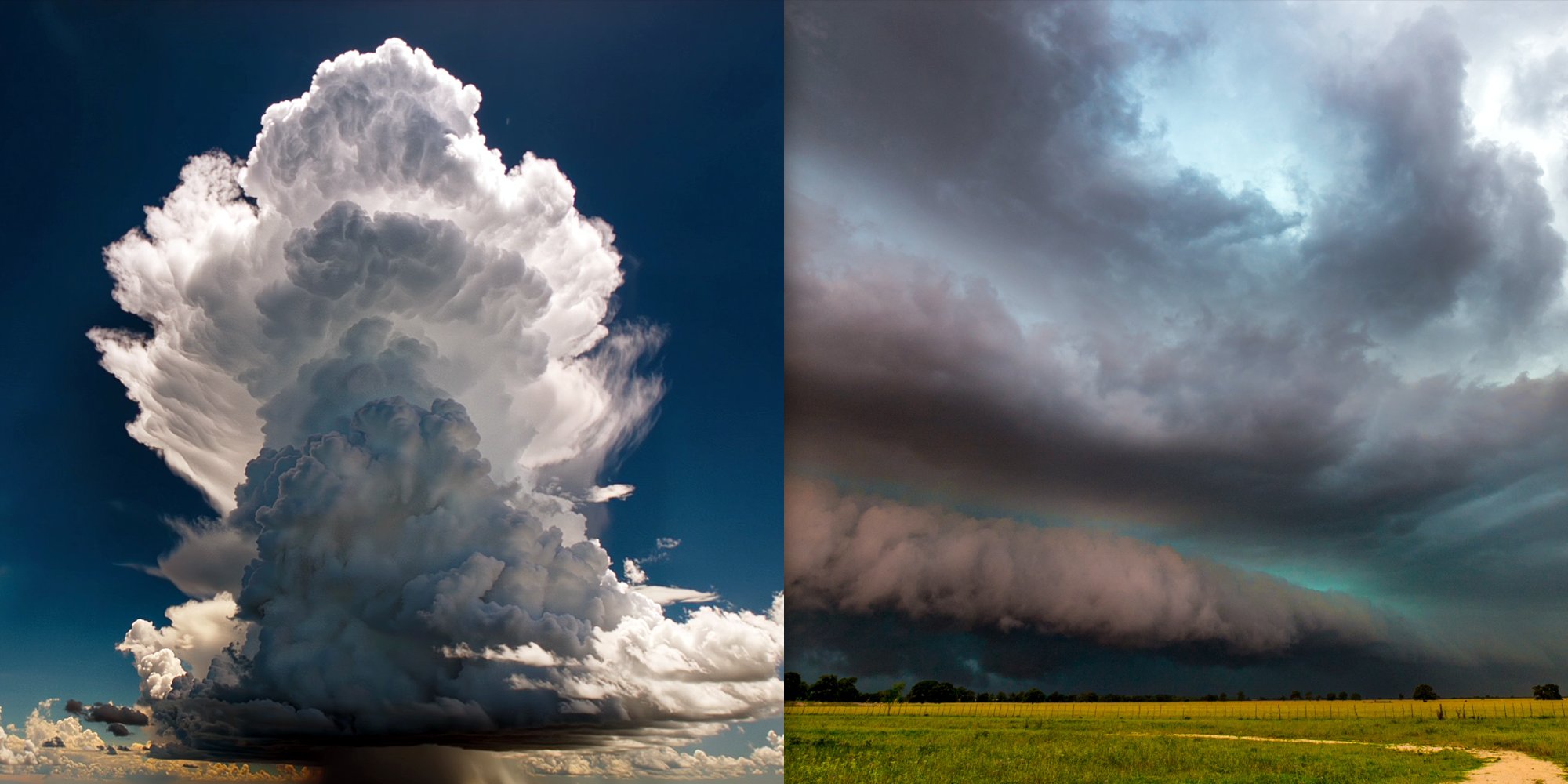
The first visible stage of thunderstorm development is the growth of cumulus clouds. Small fair-weather clouds begin building vertically as warm air continues to rise. Under favourable conditions, these clouds evolve into towering cumulus formations with the familiar cauliflower-like appearance often seen before a summer storm. Meteorologists refer to these developing clouds as cumulus congestus. At this stage, the storm is dominated almost entirely by upward-moving air known as updrafts.
If instability remains strong enough, the cloud eventually develops into a cumulonimbus cloud – the fully formed thunderstorm cloud. The mature stage begins when precipitation starts falling from the cloud and downdrafts develop alongside the updrafts. Inside the storm, powerful upward and downward air currents now coexist, creating the turbulent circulation characteristic of thunderstorms.
This is the stage during which thunderstorms produce the weather most people associate with severe convection: heavy rainfall, lightning, thunder, hail, strong wind gusts, and rapidly changing visibility. As water droplets, ice crystals, and hail particles collide inside the cloud, electrical charges begin separating. Eventually, the electrical imbalance becomes too strong and discharges as lightning. Thunder follows as the surrounding air rapidly expands after being heated by the lightning channel.
Thunderstorm Types
Some thunderstorms remain relatively weak and short-lived, while others become highly organised and dangerous. One of the key factors controlling thunderstorm intensity is vertical wind shear – the change of wind speed or direction with height. Wind shear helps separate the storm's updrafts from its downdrafts. Without this separation, falling precipitation quickly cuts off the storm's supply of warm, moist air, causing it to weaken. With sufficient wind shear, however, thunderstorms can persist for much longer and evolve into more organised systems.
The simplest type is the single-cell thunderstorm. These storms are common during summer afternoons and typically last between 30 and 60 minutes. They often form in environments with weak wind shear and mainly produce localised heavy rain, lightning, and occasional gusty winds. Although usually short-lived, they can still cause local flooding or isolated damage.
More organised storms develop when multiple thunderstorm cells interact. In multi-cell thunderstorms, new storm cells continually form while older ones dissipate. These systems can produce widespread heavy rain, hail, and strong wind gusts over larger areas. Some organise into squall lines – long bands of thunderstorms capable of producing damaging winds and intense rainfall.
The most intense and long-lasting thunderstorms are known as supercells. Unlike ordinary storms, supercells contain a rotating updraft called a mesocyclone. Their highly organised internal structure allows them to survive for many hours while producing severe weather such as giant hail, destructive winds, intense lightning activity, and tornadoes. Although relatively rare, supercells are among the atmosphere's most violent weather systems.
Thunderstorms can also produce dangerous local wind phenomena. One of the most hazardous is the microburst – a concentrated downdraft that accelerates toward the ground before spreading outward violently. Wind speeds inside microbursts can become extremely strong over very short distances, creating dangerous conditions for aviation during take-off and landing. Slow-moving thunderstorms may also produce flash flooding when heavy rainfall repeatedly affects the same area within a short period of time.
When the Storm Runs Out of Fuel
Eventually, the thunderstorm begins to weaken. As downdrafts strengthen, they cut off the storm's supply of warm, moist inflow air. Without continuous rising air to sustain cloud formation, precipitation gradually weakens and lightning becomes less frequent. The storm dissipates from the lower levels upward, often leaving behind only the high anvil cloud visible in the sky. For an ordinary thunderstorm cell, the entire lifecycle may last little more than an hour, although larger organised systems can persist for many hours and travel hundreds of kilometres.
Forecasting Atmospheric Instability
Forecasting thunderstorms remains one of the greatest operational challenges in meteorology because storm development often depends on very local processes. Small variations in moisture, instability, wind structure, or surface heating can determine whether thunderstorms intensify or fail to develop altogether. This is why meteorologists rely on several atmospheric parameters together rather than focusing on a single forecast variable.
On meteoblue weather maps, convective parameters such as CAPE, Lifted Index, Convective Inhibition (CIN), and Storm Helicity help identify environments favourable for thunderstorm development. CAPE
measures how much energy is available for rising air parcels, while the Lifted Index provides another indication of atmospheric instability. CIN represents the atmospheric "cap" that can suppress storm development even in otherwise unstable conditions. Storm Helicity adds another important dimension by highlighting areas where rotating updrafts and organised convection may develop.
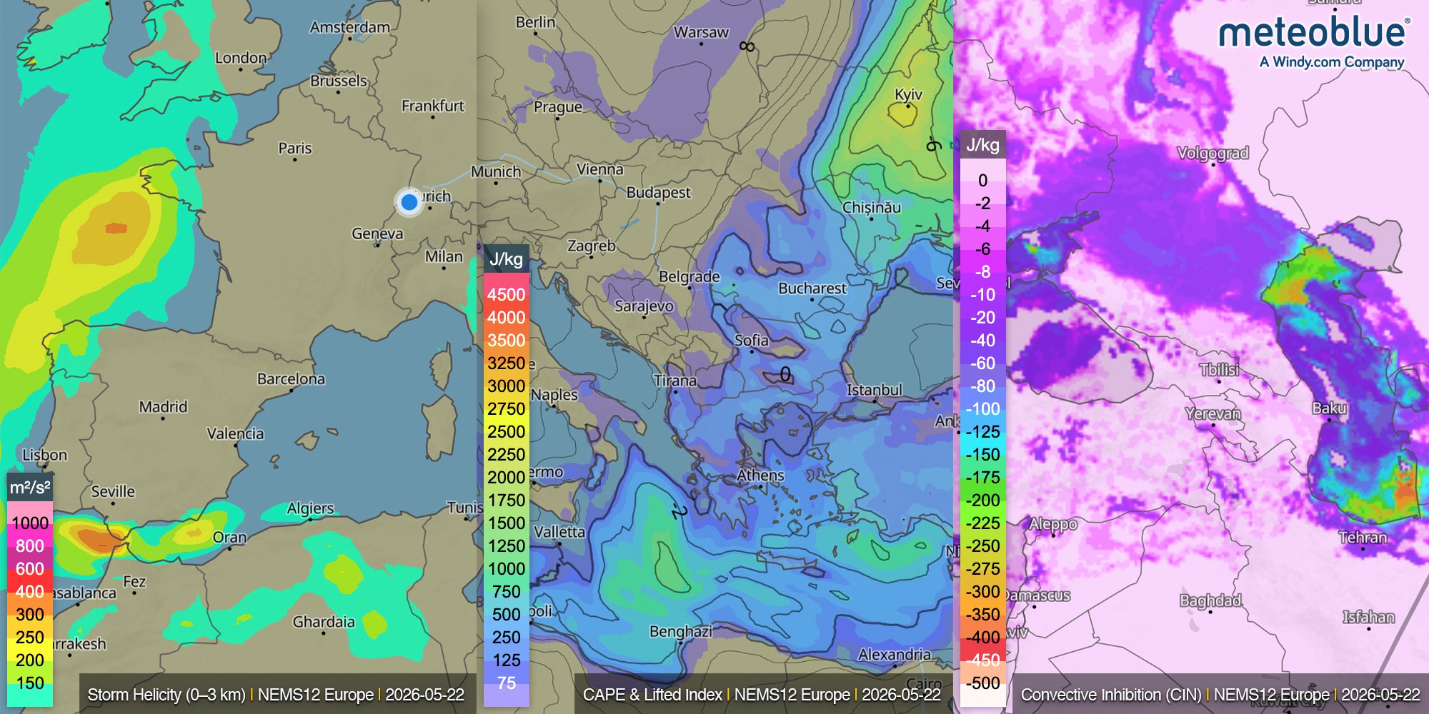
The highest convective risk often appears where several ingredients overlap: high CAPE, negative Lifted Index values, low to moderate CIN, and elevated storm helicity. Together, these parameters help meteorologists evaluate where thunderstorms may form, intensify, or become severe.
Modern thunderstorm forecasting also combines numerical weather models with real-time observations. Radar imagery allows users to track precipitation intensity and storm motion, while satellite observations reveal cloud growth and storm structure from above. Lightning detection, precipitation forecasts, and wind maps provide additional insight into evolving convective systems. Together, these tools help identify where the atmosphere is becoming unstable and where severe weather may become more likely.
A thunderstorm cell may live for less than an hour, yet during that time it can release enormous amounts of energy and dramatically alter local weather conditions. Modern forecasting tools continue improving our ability to monitor and anticipate convective storms, but uncertainty remains an inherent part of thunderstorm prediction – one of the reasons thunderstorms continue to challenge meteorologists and captivate weather observers alike.
Interested in exploring this topic further or sharing your own observations? Visit the meteoblue Community Forum, where our experts and community members continue the discussion.
