An image of our satellite map from 13-03-2023 shows how the cyclone was moving across the region.

With our high-precision satellite map, you can access historical satellite data back to 2019 in 15-minute time steps. In addition, you can animate the satellite or radar map with our unique movie function by clicking the “Play” button in the bottom right corner. This allows you to display the weather information in a seamless movie. Historical satellite data for the past 3 hours are free on our website. To extend the time range back to 2019, a point+ subscription is required.
Tropical storm "Freddy" has been raging in Southeast Africa on 13-03-2023. It hit the region of East Africa for the second time in just a few weeks, whereas the first time is also reported in our weather news. Locally, it caused stormy weather conditions with lots of rain and strong winds. Therefore, we recommend our precipitation map or weather radar to track such events since they show real-time weather conditions.

The heavy rains are also visible in our weather archive. In addition, the weather archive offers historical simulation data for every place worldwide, summarising the most important weather information.

We want to use this storm to explain a cyclone in more detail.
Generally, a cyclone can be described as a fast-rotating storm developing over the Indian Ocean. You can track the storm with our wind animation, providing a 7-day forecast. It is a storm accompanied by low atmospheric pressure, high winds, and heavy rain, usually creating destruction when hitting the land surface. Cyclones are the pendant to heavy storms in the North Atlantic Ocean, the so-called Hurricanes, or the typhoons in the northwestern Pacific Ocean.
Due to high water temperatures in tropical oceans, water begins to vapour.
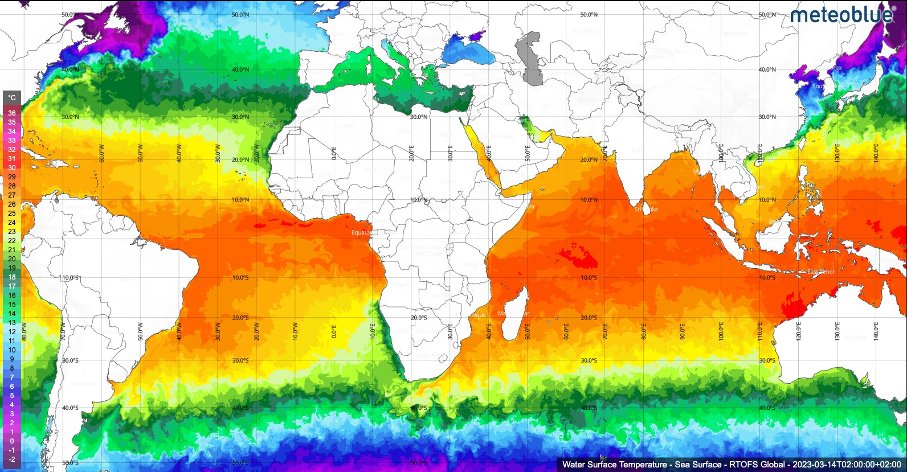
As the water vapour rises, it condensates, and clouds form. The rising of warm air creates low pressure over the ocean. Air always moves from high-pressure to low-pressure areas, which also creates wind. Under strong vapouring conditions, pressure sinks more. Therefore more (and warm) air from high-pressure regions moves towards the low-pressure centre. Steadily, warm moist air rises, creating even more dense clouds. As can be seen well in our satellite images, the clouds drift towards the low-pressure centre, the "eye" of the cyclone. Since cyclone Freddy was in the southern hemisphere, air masses rotate clockwise, caused by the earth's rotation. Finally, global winds move the cyclone back and forth, and, as in the case of Freddy, cyclones can therefore travel many kilometres.
Freddy carried much energy, high wind speeds and much moisture. Especially its long lifetime is a peculiarity. In times of climate change, the intensification of storms like these is also expected in the future.
You can find more explanations of different weather phenomena on our meteoScool pages.
