meteoblue Urban Maps provide high-resolution visualisations of key urban weather and climate patterns, including temperature, wind, thermal comfort and pluvial flood risk. Designed for city environments, the maps help residents, planners and decision-makers better understand local conditions and prepare for heat, wind exposure and heavy rainfall impacts.
Urban weather affects everyday life
Cities create their own microclimates. Buildings, roads, green spaces, water bodies and terrain all influence how heat accumulates, how wind moves through streets and how rainfall affects neighbourhoods.
As cities continue to grow and extreme weather events become more frequent, understanding these local differences is essential. A single city can contain cooler shaded areas, exposed hot spots, wind corridors and zones that are more sensitive to intense rainfall. Urban Maps make these patterns visible.
With detailed meteorological modelling and high-resolution visualisation, meteoblue Urban Maps support more informed decisions for climate adaptation, public health, urban planning and everyday city life.
In addition to air temperature, Urban Maps can display wind conditions, Physiological Equivalent Temperature (PET) and pluvial flood information. This broader view helps cities understand not only where it is hot, but also how outdoor comfort, ventilation and rainfall-related risks vary across streets, neighbourhoods and public spaces.
The impact of heat waves increases rapidly
The rapidly increasing number of heat-related deaths dramatically illustrates how the intricate balance of land use has become a pressing issue, especially as urban landscapes continue to expand and more people are moving from rural areas to cities every day. Heat waves are among the most dangerous natural hazards and especially vulnerable groups need to be protected from heat stress.
The meteoblue Urban Maps provide hyperlocal forecasts designed specifically for city environments, providing both residents and town planners with the tools to assess the impact of climate change mitigation measures, such as the targeted introduction of green spaces into an urban environment.
Our temperature maps demonstrate where small changes can make a big difference. By offering detailed meteorological insights and predictions, the meteoblue Urban Maps enable urban developers, businesses, and inhabitants alike to make informed decisions towards an enhanced quality of life in the city. Such targeted actions contribute to a more comfortable and sustainable urban future, helping urban communities to flourish in spite of a changing climate.
Global Heat Monitor - Early detection of upcoming heat waves for cities worldwide
Is your city of interest not listed? No problem: New cities can be added to the interface within a few days. Please get in touch with us and our experts will get back to you shortly. Once the city has been added, the resulting map widget can be embedded into websites and applications in a matter of minutes.
Learn moreHow to identify symptoms of heat stress
Heat exhaustion
- Faint or dizzy
- Excessive sweating
- Cool, pale, clammy skin
- Nausea or vomitting
- Rapid, weak pulse
- Muscle cramps
To prevent heat exhaustion, please refer to the recommended measures outlined below.
Heat stroke
- Throbbing headache
- No sweating
- High body temperature
- Red, hot, dry skin
- Nausea or vomiting
- Rapid, strong pulse
- May lose consciousness
Heat stroke is a life-threatening condition: Seek immediate medical help or call your local emergency service number!
How to protect yourself and others from heat stress
Make sure that you have a constant supply of drinking water and remember to drink regularly. Encourage others to do the same.
Remain indoors or in shaded, well-ventilated areas. Wear lightweight, light-coloured clothing and avoid outdoor activities around noontime.
Keep windows and blinds closed during the day and ventilate at night. Take cool showers or wet your skin with a damp cloth to enhance comfort.
Schedule activities during the coolest parts of the day and avoid exercising in the heat.
Look out for vulnerable groups such as young children, the elderly, pregnant women, and individuals with medical conditions. Be vigilant for symptoms of heat-induced illnesses.

Temperature Maps close to you
meteoblue Urban Maps are available for selected cities and can be extended to new locations. The maps can be integrated into websites and applications, helping cities, organisations and residents access detailed local information in an intuitive visual format. For cities using local measurement networks, model data can be compared with ground observations to improve accuracy and monitor the effectiveness of adaptation measures over time.
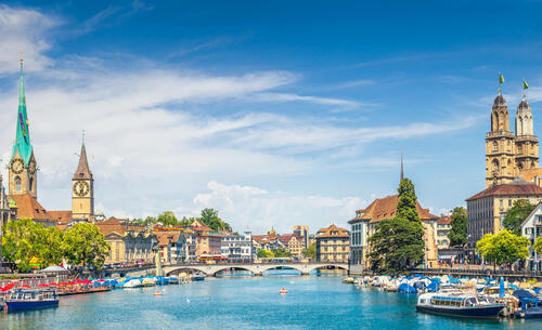
Wind Map - Showcase for Zurich
Urban wind maps show how wind speed and direction vary within the city. Buildings, street canyons, open spaces and local terrain can strongly influence wind flow, creating sheltered zones, ventilation corridors or exposed areas. This information can support urban design, public space planning, comfort assessments, infrastructure planning and the evaluation of how wind interacts with heat and air quality conditions.
Beyond the high-resolution temperature display, the meteoblue Urban Maps can be upgraded with a range of useful features, including a 7-day forecast option, real-time precipitation radar overlay, and the hyperlocal 2 m wind field animation, demonstrated above through the example of the digital twin of the city of Zurich, Switzerland.
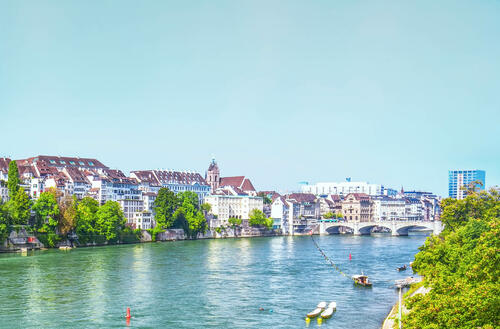
PET Maps - Showcase for Zurich
Physiological Equivalent Temperature, or PET, describes how weather conditions feel to the human body. It combines several factors that influence thermal comfort, including air temperature, humidity, wind and radiation.
PET maps therefore provide a more human-centred view of urban heat stress than air temperature alone. They help show where outdoor conditions may feel uncomfortable or potentially dangerous, especially for vulnerable groups during heat events.
Cities with active City Climate Monitoring Systems
Urban Maps support cities in identifying local climate patterns, communicating risks and planning targeted adaptation measures. Whether the focus is heat mitigation, outdoor comfort, wind exposure or rainfall-related risks, the maps provide a detailed spatial view of the conditions that shape urban life.
This project has received funding from European Union's "Horizon 2020 Research and Innovation Programme" under the Grant Agreement 101004112.