Despite a brief period of cold temperatures in early December, the winter in Europe has been very warm thus far, significantly warmer than the mean, as can be seen in our Climate Comparison.
Several places in Central and Eastern Europe witnessed extremely high temperatures during the past Holiday Season, which can be observed in our temperature anomaly weather maps:
- One of the highest December minimum temperatures were observed in Germany and France. As seen in our Weather Archive for Freiburg, minimum temperatures stayed above 10°C on 29.12.22 throughout day and night.
- In several cities, especially in France, Spain and Switzerland, maximum daily temperatures reached 20°C during New Year's Eve and new year day, which can be seen in the example of Malaga (Spain).
The past temperatures for December can be easily accessed with our Weather Archive, which provides access to historical weather data since 1984 for every place on Earth.
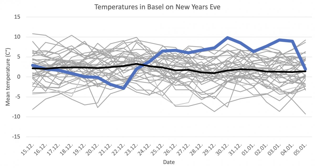
When comparing the last two weeks' temperatures, the prior year was warmer than typical, as seen by the blue line. A black line represents average over the last 40 years. On New Year's Eve, a significant temperature difference of roughly eight Kelvin can be seen while analyzing this chart. The graph is based on the mean daily temperature for Basel. The historical data is part of our history+ subscription, which is globally available since 1984.
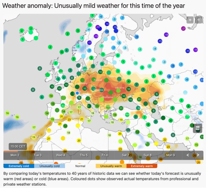
Unusual temperatures are displayed on our start page, where a map appears in case of unusual warm or cold temperatures. The orange and red areas indicate higher temperatures than normal are observed. The comparison is based on 40 years of historical weather data from our unique simulation models.
The unusual warm atmospheric conditions in Central Europe during New Year’s Eve were caused by warm air masses from the Iberian Peninsula and Africa, which were transported towards Central Europe by a south-western atmospheric flow. This south-western flow is usually caused by a low-pressure system located over the Atlantic Ocean near Island and a high pressure system over Central Europe The development of high and low-pressure systems can easily be analysed by our sea level pressure weather map. The situation described above usually happens when jet stream wind from the North Atlantic Ocean flow towards Skandinavia. The development of the jet stream is visualized in our wind animation.
