
Weather models comparison for Mount Everest
- Every model is assigned one colour that is used in all diagrams. The legend next to the diagram has a list with the model names and the corresponding colours.
- The first diagram shows the predicted temperatures for each model. The yellow background indicates daylight. The dashed line represents the average of all models.
- The second diagram shows precipitation amounts: Blue bars indicate precipitation in mm accumulated over one hour. The bars get darker when more models predict precipitation.
- Weather icons are used to display the predicted weather conditions in the third diagram. The background is light blue for clear sky, light grey for light clouds, and dark grey for strong clouds.
The variables shown are from direct model output and not scaled to the exact altitude and position of the selected place.
Frequently, forecasts are spot on, sometimes less accurate and a few times they are completely wrong. It would be great to know in advance if the forecast is likely to be correct, but how? All weather forecasts are computed by computer models, and sometimes these differ significantly, which indicates uncertainty and difficulty to make an accurate forecast of the weather. In such cases, the weather forecast is likely to change on a daily basis. Our MultiModel diagram shows the weather forecast of multiple models from meteoblue and others, mostly national weather agencies. Generally, the uncertainty of the forecast increases with the differences between models.
What to do if the forecast is uncertain?
- Develop alternatives for your decisions, which are feasible with every possible weather development.
- Check forecast updates more frequently.
- Check the progress of actual weather more frequently.
- Postpone important activities, if they depend strongly on weather.
Forecast limitations
- Thunderstorms: The exact placement and timing of thunderstorms are almost impossible to predict and the associated amount of precipitation or hail can vary significantly.
- Stratus clouds: Fog and low clouds are often invisible to most models and to satellites, and as such models may agree despite uncertainty. As a result, models may overestimate sunny conditions in areas prone to fog.
- Topography: Complex mountain terrain is very challenging for weather predictions. Low clouds and precipitation can rapidly develop there without being detected, and will then not be sufficiently considered in the weather model.
These weather patterns are very difficult to forecast, vary in place and time or depend on local terrain. While locally forecast precipitation does not occur, it might rain just a few kilometres away. A cold front could arrive a few hours later or thunderstorms might or might not develop. Such conditions are error prone and should be handled carefully. In some cases, even different models may not detect such conditions.
Weather models
Weather models simulate physical processes. A weather model divides the world or a region into small "grid-cells". Each cell is about 4km to 40km wide and 100m to 2km high. Our models contain 60 atmospheric layers and reach deep into the stratosphere at 10-25 hPa (60km altitude). The weather is simulated by solving complex mathematical equations between all grid cells every few seconds and parameters like temperature, wind speed or clouds are stored for every hour.
meteoblue operates a large number of weather models and integrates open data from various sources. All meteoblue models are computed twice a day on a dedicated High Performance Cluster.
| Model | Region | Resolution | Last update | Source | |
|---|---|---|---|---|---|
|
NEMS model family: Improved NMM successors (operational since 2013). NEMS is a multi-scale model (used from global down to local domains) and significantly improves cloud-development and precipication forecast. |
|||||
|
Table legend (left to right): region, resolution, source and last updated |
|||||
| NEMS-4 | Central Europe | 4.0 km | 72 h | 06:01 UTC | meteoblue |
| NEMS-12 | Europe | 12.0 km | 180 h | 06:27 UTC | meteoblue |
| NEMS-30 | Global | 30.0 km | 180 h | 04:39 UTC | meteoblue |
| NEMS-8 | New Zealand | 8.0 km | 180 h | 09:45 UTC | meteoblue |
| NEMS-10 | India | 10.0 km | 180 h | 08:47 UTC | meteoblue |
| NEMS-8 | Japan East Asia | 8.0 km | 180 h | 09:39 UTC | meteoblue |
| NEMS-12 | Central America | 12.0 km | 180 h | 09:21 UTC | meteoblue |
| NEMS-10 | South Africa | 10.0 km | 180 h | 08:51 UTC | meteoblue |
| NEMS2-12 | Europe | 12.0 km | 168 h | 23:05 UTC | meteoblue |
| NEMS2-30 | Global | 30.0 km | 168 h | 22:32 UTC | meteoblue |
| NEMS-10 | South America | 10.0 km | 180 h | 08:05 UTC | meteoblue |
|
NMM model family: the first weather model from meteoblue (operational since 2007). NMM is a regional weather model and highly optimised for complex terrain. |
|||||
| NMM-4 | Central Europe | 4.0 km | 72 h | 05:26 UTC | meteoblue |
| NMM-12 | Europe | 12.0 km | 180 h | 06:49 UTC | meteoblue |
| NMM-18 | South Africa | 18.0 km | 180 h | 07:23 UTC | meteoblue |
| NMM-18 | South America | 18.0 km | 180 h | 08:56 UTC | meteoblue |
| NMM-18 | Southeast Asia | 18.0 km | 180 h | 07:56 UTC | meteoblue |
|
Third-party domains: As seen on most other websites |
|||||
| IFSENS-20 | Global | 20.0 km | 360 h (3-hourly) | 23:32 UTC | ECMWF |
| GFSENS-40 | Global | 40.0 km | 384 h (3-hourly) | 06:52 UTC | NOAA NCEP |
| GFS-25 | Global | 22.0 km | 180 h (3-hourly) | 16:32 UTC | NOAA NCEP |
| GFS-12 | Global | 12.0 km | 180 h (3-hourly) | 04:54 UTC | NOAA NCEP |
| IFS-20 | Global | 20.0 km | 144 h (3-hourly) | 08:45 UTC | ECMWF |
| ICON-12 | Global | 13.0 km | 180 h (3-hourly) | 05:40 UTC | Deutscher Wetterdienst |
| ICON-7 | Europe | 7.0 km | 120 h (3-hourly) | 04:25 UTC | Deutscher Wetterdienst |
| ICOND-2 | Germany and Alps | 2.0 km | 48 h | 08:16 UTC | Deutscher Wetterdienst |
| HARMN-5 | Central Europe | 5.0 km | 60 h | 05:24 UTC | KNMI |
| GFS-40 | Global | 40.0 km | 180 h (3-hourly) | 04:52 UTC | NOAA NCEP |
| NAM-12 | North America | 12.0 km | 84 h (3-hourly) | 03:07 UTC | NOAA NCEP |
| NAM-5 | North America | 5.0 km | 48 h | 05:20 UTC | NOAA NCEP |
| NAM-3 | North America | 3.0 km | 60 h | 03:48 UTC | NOAA NCEP |
| HRRR-2 | North America | 3.0 km | 17 h | 09:27 UTC | NOAA NCEP |
| FV3-5 | Alaska | 5.0 km | 48 h | 23:30 UTC | NOAA NCEP |
| ARPEGE-25 | Global | 25.0 km | 96 h (3-hourly) | 04:49 UTC | METEO FRANCE |
| ARPEGE-11 | Europe | 11.0 km | 96 h | 04:03 UTC | METEO FRANCE |
| AROME-2 | France | 2.0 km | 42 h | 03:58 UTC | METEO FRANCE |
| UKMO-10 | Global | 10.0 km | 144 h (3-hourly) | 06:22 UTC | UK MET OFFICE |
| GEM-15 | Global | 15.0 km | 168 h (3-hourly) | 09:06 UTC | Environment Canada |
| RDPS-2 | North America | 2.5 km | 48 h | 06:58 UTC | Environment Canada |
| MSM-5 | Japan | 5.0 km | 78 h | 23:26 UTC | Japan Meteorological Agency |
| UKMO-2 | UK/France | 2.0 km | 120 h (3-hourly) | 06:31 UTC | UK MET OFFICE |
| NBM-2 | North America | 2.5 km | 180 h (3-hourly) | 07:30 UTC | NOAA NCEP |
| WRFAMS-7 | South America | 7.0 km | 168 h | 11:53 UTC | CPTEC/INPE |
| AIFS-25 | Global | 25.0 km | 180 h (3-hourly) | 08:16 UTC | ECMWF |
| IFS-HRES | Global | 10.0 km | 144 h (3-hourly) | 07:51 UTC | ECMWF |
| ICON-I2 | Italy & Alps | 2.0 km | 72 h | 03:31 UTC | Italia Meteo |
| CAMS-10 | Europe | 10.0 km | 96 h | 10:02 UTC | ECMWF Copernicus |
| CAMS-40 | Global | 40.0 km | 120 h (3-hourly) | 10:09 UTC | ECMWF Copernicus |
| WW3-25 | Global | 25.0 km | 180 h (3-hourly) | 07:14 UTC | NOAA NCEP |
| WW3-4 | Baltic/Arctic | 4.0 km | 72 h | 09:45 UTC | MET Norway |
| GWAM-25 | Global | 25.0 km | 174 h (3-hourly) | 04:34 UTC | DWD |
| EWAM-5 | Europe | 5.0 km | 78 h | 04:43 UTC | DWD |
| MFWAM-8 | Global | 8.0 km | 228 h (3-hourly) | 09:46 UTC | Copernicus / MeteoFrance |
| MEDWAM-4 | Mediterranean | 4.0 km | 204 h | 06:33 UTC | Copernicus |
| IBIWAM-3 | Iberian Biscay Irish | 3.0 km | 216 h | 03:15 UTC | Copernicus |
| BALWAM-2 | Baltic | 2.0 km | 144 h | 22:29 UTC | Copernicus / FMI |
| RTOFS-9 | Global | 9.0 km | 192 h (3-hourly) | 01:09 UTC | NOAA NCEP |
Worldwide coverage
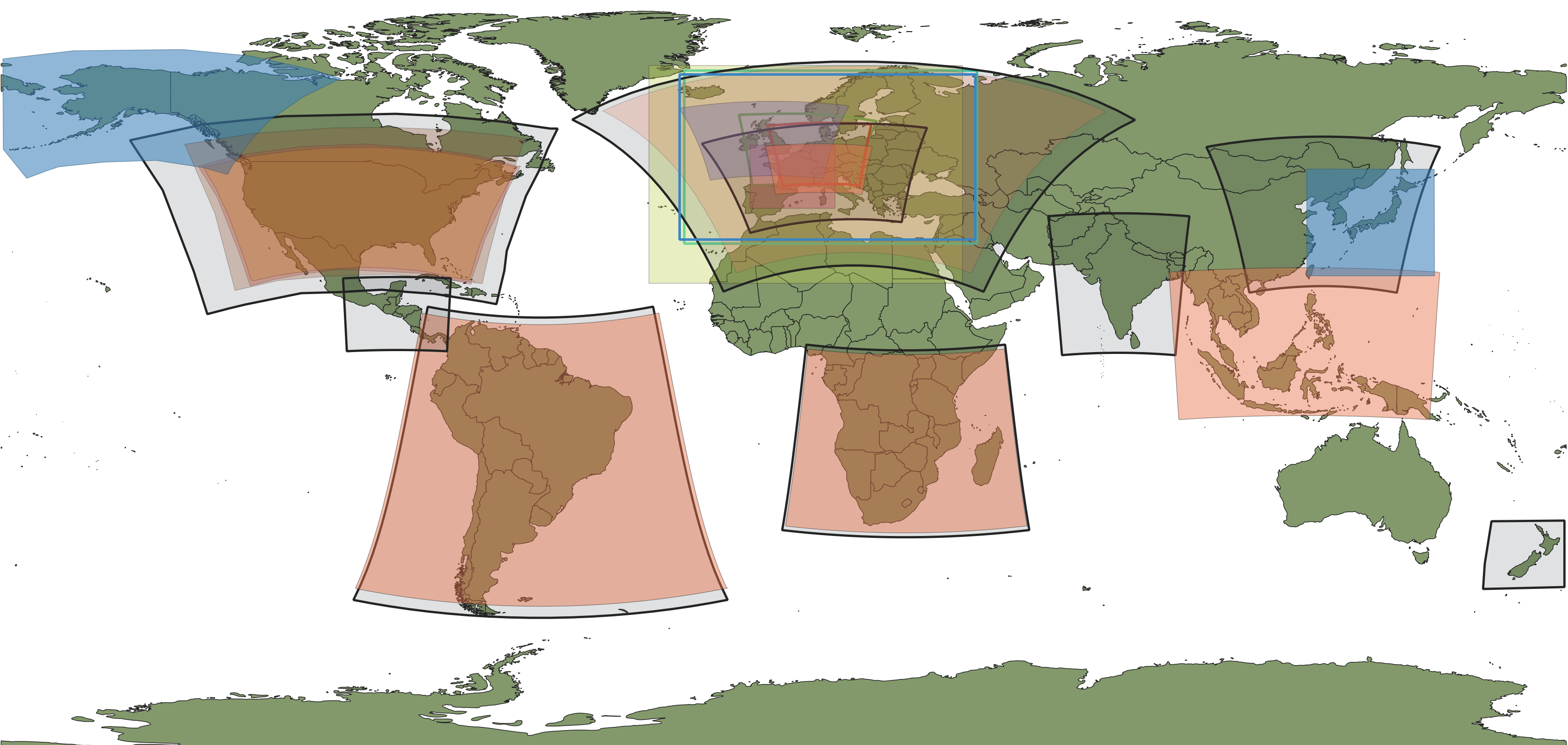
meteoblue weather models cover most populated areas at high resolution (3-10km) and world wide at moderate resolution (30km). The map on the side displays NMM models as red and NEMS models as black boxes. Other colors show third-party models. Global models are not shown. For a single forecast, multiple weather models, statistical analysis, measurements, radar and satellite telemetry are considered and combined to generate the most probable weather forecast for any given location on Earth.


