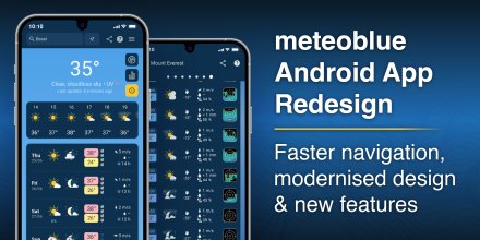
AD FREE

Remove ads for 9 € per year
- 3h
3-hourly view
3h 1h
General Sea & Surf
Icon
Overcast
Partly cloudy
Dusty
Dusty
Dusty
Clear with few low clouds
Partly cloudy
Partly cloudy
°F
69°
69°
73°
77°
77°
74°
70°
68°
°F
67°
67°
72°
80°
76°
71°
69°
67°
WSW
W
WNW
NNW
ENE
SE
SSE
W
mph
6-15
5-11
5-11
1-9
5-16
7-12
5-12
4-12
μg/m³

Dust Levels High

Current concentration: 135 μg/m³.

Dust Levels Very High

Current concentration: 198 μg/m³.

Dust Levels Very High

Current concentration: 321 μg/m³.

Dust Levels Very High

Current concentration: 348 μg/m³.

Dust Levels Very High

Current concentration: 332 μg/m³.

Dust Levels Very High

Current concentration: 259 μg/m³.

Dust Levels Very High

Current concentration: 273 μg/m³.

Dust Levels Very High

Current concentration: 271 μg/m³.
in
-
-
-
-
-
-
-
-
%
25%
10%
0%
0%
0%
0%
0%
0%
in

00:00 to 01:00:
25% chance of precipitation in the area.
0″ are predicted by our local models.

01:00 to 02:00:
25% chance of precipitation in the area.
0″ are predicted by our local models.

02:00 to 03:00:
25% chance of precipitation in the area.
0″ are predicted by our local models.

03:00 to 04:00:
10% chance of precipitation in the area.
0″ are predicted by our local models.

04:00 to 05:00:
0% chance of precipitation in the area.
0″ are predicted by our local models.

05:00 to 06:00:
0% chance of precipitation in the area.
0″ are predicted by our local models.

06:00 to 07:00:
0% chance of precipitation in the area.
0″ are predicted by our local models.

07:00 to 08:00:
0% chance of precipitation in the area.
0″ are predicted by our local models.

08:00 to 09:00:
0% chance of precipitation in the area.
0″ are predicted by our local models.

09:00 to 10:00:
0% chance of precipitation in the area.
0″ are predicted by our local models.

10:00 to 11:00:
0% chance of precipitation in the area.
0″ are predicted by our local models.

11:00 to 12:00:
0% chance of precipitation in the area.
0″ are predicted by our local models.

12:00 to 13:00:
0% chance of precipitation in the area.
0″ are predicted by our local models.

13:00 to 14:00:
0% chance of precipitation in the area.
0″ are predicted by our local models.

14:00 to 15:00:
0% chance of precipitation in the area.
0″ are predicted by our local models.

15:00 to 16:00:
0% chance of precipitation in the area.
0″ are predicted by our local models.

16:00 to 17:00:
0% chance of precipitation in the area.
0″ are predicted by our local models.

17:00 to 18:00:
0% chance of precipitation in the area.
0″ are predicted by our local models.

18:00 to 19:00:
0% chance of precipitation in the area.
0″ are predicted by our local models.

19:00 to 20:00:
0% chance of precipitation in the area.
0″ are predicted by our local models.

20:00 to 21:00:
0% chance of precipitation in the area.
0″ are predicted by our local models.

21:00 to 22:00:
0% chance of precipitation in the area.
0″ are predicted by our local models.

22:00 to 23:00:
0% chance of precipitation in the area.
0″ are predicted by our local models.

23:00 to 00:00:
0% chance of precipitation in the area.
0″ are predicted by our local models.

12.4 mi
Sea/surf forecast
Significant wave height (m)
0.6
0.6
0.4
0.4
0.3
0.3
0.3
0.3
0.3
0.3
0.2
0.2
0.2
0.2
0.2
0.2
Significant wave direction in which the waves move
Water temperature (°F)
67°
67°
67°
68°
69°
69°
68°
68°
Swell wave height (m)
0.3
0.3
0.4
0.4
0.3
0.3
0.3
0.3
0.3
0.3
0.2
0.2
0.2
0.2
0.2
0.2
Swell wave period (s)
3.9
3.9
3.6
3.6
3.6
3.6
3.5
3.5
3.6
3.6
3.6
3.6
3.6
3.6
3.6
3.6
Wind wave direction in which the waves move
Wind wave height (m)
0.4
0.4
0.1
0.1
0.1
0.1
0
0
0
0
0
0
0
0
0
0
Wind wave period (s)
2.5
1.6
1.4
1
1.3
1.4
1.4
1.4
Overcast
Partly cloudy
Dusty
Dusty
Dusty
Clear with few low clouds
Partly cloudy
Partly cloudy
69°
69°
73°
77°
77°
74°
70°
68°
67°
67°
72°
80°
76°
71°
69°
67°
WSW
6-15
W
5-11
WNW
5-11
NNW
1-9
ENE
5-16
SE
7-12
SSE
5-12
W
4-12
μg/m³

Dust Levels High

Current concentration: 135 μg/m³.

Dust Levels Very High

Current concentration: 198 μg/m³.

Dust Levels Very High

Current concentration: 321 μg/m³.

Dust Levels Very High

Current concentration: 348 μg/m³.

Dust Levels Very High

Current concentration: 332 μg/m³.

Dust Levels Very High

Current concentration: 259 μg/m³.

Dust Levels Very High

Current concentration: 273 μg/m³.

Dust Levels Very High

Current concentration: 271 μg/m³.
-
25%
-
10%
-
0%
-
0%
-
0%
-
0%
-
0%
-
0%
The weather forecast has high predictability. Compare different forecasts with MultiModel.

Weather report for Ar Rumaythīyah

Overnight into Tuesday it is mostly cloudy, but on Tuesday morning the sky clears. For the afternoon a few clouds are expected. It is a sunny day. Temperatures as high as 78 °F are foreseen. The UV-Index climbs up to 7, don't forget to use sunscreen when spending the day outside. Overnight into Tuesday a gentle breeze is expected (8 to 12 mph). During the day blows a light breeze (4 to 8 mph). From time to time gusts could reach up to 21 mph. Winds blowing overnight from Southwest, in the morning from West and during the afternoon from Southeast. The weather forecast for Ar Rumaythīyah for Tuesday is likely to be accurate.

sun-icon
UV 7
05:37
18:06
Waxing gibbous moon (161°)
16:40
04:32

Pressure: 1011 hPa

Timezone: GMT+03 (UTC +03:00h)

Hourly weather forecast for Ar Rumaythīyah

Our 5-day meteogram for Ar Rumaythīyah offers all weather information in 3 simple graphs: [More]
  • Temperature chart with weather pictograms. The yellow background indicates daylight.
  • Clouds in different altitudes: from few clouds (light grey) to overcast (dark grey). Dark blue bars show hourly precipitation and light blue showers. An asterisk indicates snow fall.
  • Forecasts for wind speeds are blue and for gusts are green. The arrowheads point in the same direction as the wind.

You can embed this meteogram into your own website. Customize it here.

Live satellite map, Kuwait

The location marker is placed on Ar Rumaythīyah. [More]

The real-time satellite image combines visible light during daytime with infrared radiation during nighttime. At night, the image is not dark as infrared radiation can detect temperature differences. Unfortunately, low clouds and fog are difficult to distinguish from ground temperatures and thus can be almost invisible during the night. Meteosat satellite images for Europe are updated in real-time every 5 minutes. GOES-16/GOES-17 (North & South America) and Himawari (Asia) images update every 10 minutes.

Precipitation is estimated from radar and satellites. Precipitation estimates from satellites are less accurate at night than during daytime.

© 2026 meteoblue, NOAA Satellites GOES-16 and EUMETSAT. Lightning data provided by nowcast.

Radar and precipitation nowcast, Kuwait

Drizzle
Light
Moderate
Heavy
Very Heavy
Hail

The location marker is placed on Ar Rumaythīyah. This animation shows the precipitation radar for the selected time range, as well as a 2h forecast. Orange crosses indicate lightning. Data provided by nowcast.de (available in USA, Europe, Australia). Drizzle or light snow fall might be invisible for the radar. Precipitation intensity is colour coded, ranging from turquoise to red.

Wind map for Ar Rumaythīyah

Back to top
×
Hey there,
seems like you are using an ad blocker.

Advertising is essential to maintain our free website with unique detail and accuracy.

Please whitelist www.meteoblue.com on your ad blocker or consider buying one of our products:

Already have a subscription?
Then please login.