News

meteoblue Spring Day 2026
Bringing the team together for fun, exchange and valuable discussions.
Read on

Bringing the team together for fun, exchange and valuable discussions.
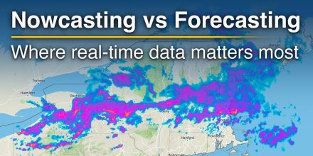
Short-term weather decisions often depend less on what might happen tomorrow and more on what is already unfolding now.
|
|
|
|
|
|
|
|
||
|
Icon
|

|
|

|

|
|
|

|

|
|
°F
|
82°
|
81°
|
93°
|
101°
|
102°
|
98°
|
92°
|
88°
|
|
°F
|
76°
|
76°
|
83°
|
95°
|
96°
|
89°
|
81°
|
78°
|
|
|
NNE |
NE |
ENE |
ENE |
ENE |
NE |
NNE |
NNE |
|
mph
|
9-18
|
9-17
|
16-21
|
13-18
|
11-17
|
11-23
|
15-23
|
13-22
|
|
μg/m³
|
Dust Levels Very High
Current concentration:
368 μg/m³.
|
Dust Levels Very High
Current concentration:
359.67 μg/m³.
|
Dust Levels Extremely High
Current concentration:
494.67 μg/m³.
|
Dust Levels Extremely High
Current concentration:
572 μg/m³.
|
Dust Levels Extremely High
Current concentration:
577.33 μg/m³.
|
Dust Levels Extremely High
Current concentration:
571.33 μg/m³.
|
Dust Levels Extremely High
Current concentration:
776.67 μg/m³.
|
Dust Levels Extremely High
Current concentration:
813.67 μg/m³.
|
|
in
|
-
|
-
|
-
|
-
|
-
|
-
|
-
|
-
|
|
%
|
0%
|
0%
|
0%
|
0%
|
0%
|
0%
|
0%
|
0%
|
|
in
|
||||||||
|
|
No precipitation expected |
|||||||
|
12.4 mi
|
||||||||
Until noon the sky remains overcast but the clouds break up a bit in the afternoon. The sun will not be visible. Temperatures as high as 103 °F are foreseen. Overnight into Sunday a gentle breeze is expected (8 to 12 mph). In the course of day expect a moderate breeze (12 to 18 mph). Winds blowing at night and in the afternoon from Northeast and in the morning from East. The weather forecast for Batha Region for Sunday is expected to be very accurate.

Pressure: 1009 hPa
Timezone: WAT (UTC +01:00h)
Until noon the sky remains overcast but the clouds break up a bit in the afternoon. The sun will not be visible. Temperatures as high as 103 °F are foreseen. Overnight into Sunday a gentle breeze is expected (8 to 12 mph). In the course of day expect a moderate breeze (12 to 18 mph). Winds blowing at night and in the afternoon from Northeast and in the morning from East. The weather forecast for Batha Region for Sunday is expected to be very accurate.
Pressure: 1009 hPa
Timezone: WAT (UTC +01:00h)
You can embed this meteogram into your own website. Customize it here.
The real-time satellite image combines visible light during daytime with infrared radiation during nighttime. At night, the image is not dark as infrared radiation can detect temperature differences. Unfortunately, low clouds and fog are difficult to distinguish from ground temperatures and thus can be almost invisible during the night. Meteosat satellite images for Europe are updated in real-time every 5 minutes. GOES-16/GOES-17 (North & South America) and Himawari (Asia) images update every 10 minutes.
Precipitation is estimated from radar and satellites. Precipitation estimates from satellites are less accurate at night than during daytime.
© 2026 meteoblue, NOAA Satellites GOES-16 and EUMETSAT. Lightning data provided by nowcast.
The location marker is placed on Batha Region. Orange crosses indicate lightning. Data provided by nowcast.de (available in USA, Europe, Australia). Drizzle or light snow fall might be invisible for the radar. Precipitation intensity is colour coded, ranging from turquoise to red.
Bringing the team together for fun, exchange and valuable discussions.
Short-term weather decisions often depend less on what might happen tomorrow and more on what is already unfolding now.
Advertising is essential to maintain our free website with unique detail and accuracy.
Please whitelist www.meteoblue.com on your ad blocker or consider buying one of our products:
Already have a subscription?
Then please login.


 Zéfére


