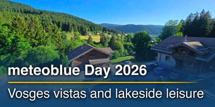
meteoblue Ad-free 9 €
Icon
Mixed with cirrus with some thunderstorm clouds possible
Clear with few low clouds and few cirrus
Clear but hazy with cirrus
Rain, thunderstorms likely
Mixed with cirrus with some thunderstorm clouds possible
Clear with few low clouds and cirrus
Mixed with cirrus with some thunderstorm clouds possible
Temperature (°F)
79°
79°
79°
79°
84°
84°
87°
87°
86°
86°
83°
83°
80°
80°
80°
80°
Temperature felt (°F)
89°
90°
96°
99°
95°
91°
88°
89°
Wind direction
SE
SSE
ESE
E
ENE
ENE
E
E
Wind speed (mph)
SE
2-5
2-5
SSE
3-5
3-5
ESE
6-10
6-10
E
8-14
8-14
ENE
8-15
8-15
ENE
8-13
8-13
E
5-9
5-9
E
4-8
4-8
Precipitation (in/3h)
-
30%
-
-
30%
-
-
50%
-
0.20 in
70%
0.20
0.26 in
60%
0.26
-
50%
-
-
40%
-
-
30%
-
Precipitation probability
30%
30%
50%
70%
60%
50%
40%
30%
Precipitation hourly

00:00 to 01:00:
20% chance of precipitation in the area.
0″ are predicted by our local models.

01:00 to 02:00:
10% chance of precipitation in the area.
0″ are predicted by our local models.

02:00 to 03:00:
30% chance of precipitation in the area.
0″ are predicted by our local models.

03:00 to 04:00:
30% chance of precipitation in the area.
0″ are predicted by our local models.

04:00 to 05:00:
30% chance of precipitation in the area.
0″ are predicted by our local models.

05:00 to 06:00:
30% chance of precipitation in the area.
0″ are predicted by our local models.

06:00 to 07:00:
20% chance of precipitation in the area.
0″ are predicted by our local models.

07:00 to 08:00:
40% chance of precipitation in the area.
0″ are predicted by our local models.

08:00 to 09:00:
50% chance of precipitation in the area.
0″ are predicted by our local models.

09:00 to 10:00:
70% chance of precipitation in the area.
0.09″ are predicted by our local models.

10:00 to 11:00:
60% chance of precipitation in the area.
0″ are predicted by our local models.

11:00 to 12:00:
70% chance of precipitation in the area.
0.1″ are predicted by our local models.

12:00 to 13:00:
60% chance of precipitation in the area.
0.13″ are predicted by our local models.

13:00 to 14:00:
60% chance of precipitation in the area.
0.13″ are predicted by our local models.

14:00 to 15:00:
50% chance of precipitation in the area.
0″ are predicted by our local models.

15:00 to 16:00:
50% chance of precipitation in the area.
0″ are predicted by our local models.

16:00 to 17:00:
30% chance of precipitation in the area.
0″ are predicted by our local models.

17:00 to 18:00:
40% chance of precipitation in the area.
0″ are predicted by our local models.

18:00 to 19:00:
40% chance of precipitation in the area.
0″ are predicted by our local models.

19:00 to 20:00:
20% chance of precipitation in the area.
0″ are predicted by our local models.

20:00 to 21:00:
30% chance of precipitation in the area.
0″ are predicted by our local models.

21:00 to 22:00:
20% chance of precipitation in the area.
0″ are predicted by our local models.

22:00 to 23:00:
30% chance of precipitation in the area.
0″ are predicted by our local models.

23:00 to 00:00:
30% chance of precipitation in the area.
0″ are predicted by our local models.

rainSPOT Precipitation distribution within 20 km
Sea/surf forecast
Significant wave height (m)
0.4
0.4
0.3
0.3
0.3
0.3
0.4
0.4
0.3
0.3
0.3
0.3
0.3
0.3
0.4
0.4
Significant wave direction in which the waves move
Water temperature (°F)
86°
86°
86°
86°
86°
86°
86°
86°
Sea/surf forecast
1h view
Hourly view
The weather forecast has medium predictability. Compare different forecasts with MultiModel.

Weather report for Georgetown

Overnight into Thursday a few clouds are expected and in the course of day a mixture of sunshine and clouds with the possibility of local thunderstorms. It is a sunny day. There is a high chance of Precipitation near 70%. Temperatures peaking at 87 °F. With a UV-Index as high as 11 make sure to properly protect your skin. Overnight into Thursday blows a light breeze (4 to 8 mph). In the course of day a gentle breeze is expected (8 to 12 mph). Winds blowing overnight from Southeast and by day from East. The weather forecast for Georgetown for Thursday can be accurate in parts but deviations are expected. Check again for latest updates.

sun-icon
UV 11
05:41
18:01
Waxing gibbous moon (120°)
14:18
02:11

Pressure: 1010 hPa

Timezone: GMT-04 (UTC -04:00h)

Radar for Georgetown

Drizzle
Light
Moderate
Heavy
Very Heavy
Hail

The location marker is placed on Georgetown. Orange crosses indicate lightning. Data provided by nowcast.de (available in USA, Europe, Australia). Drizzle or light snow fall might be invisible for the radar. Precipitation intensity is colour coded, ranging from turquoise to red.

Meteogram - 5 days - Georgetown

meteoblue
Our 5-day meteogram for Georgetown offers all weather information in 3 simple graphs: [More]
  • Temperature chart with weather pictograms. The yellow background indicates daylight.
  • Clouds in different altitudes: from few clouds (light grey) to overcast (dark grey). Dark blue bars show hourly precipitation and light blue showers. An asterisk indicates snow fall.
  • Forecasts for wind speeds are blue and for gusts are green. The arrowheads point in the same direction as the wind.

You can embed this meteogram into your own website with the following HTML code. In doing so, you agree to our non-commercial use conditions.

Current satellite images for Georgetown, Guyana

The location marker is placed on Georgetown. [More]

The real-time satellite image combines visible light during daytime with infrared radiation during nighttime. At night, the image is not dark as infrared radiation can detect temperature differences. Unfortunately, low clouds and fog are difficult to distinguish from ground temperatures and thus can be almost invisible during the night. Meteosat satellite images for Europe are updated in real-time every 5 minutes. GOES-16/GOES-17 (North & South America) and Himawari (Asia) images update every 10 minutes.

Precipitation is estimated from radar and satellites. Precipitation estimates from satellites are less accurate at night than during daytime.

© 2024 meteoblue, NOAA Satellites GOES-16 and EUMETSAT. Lightning data provided by nowcast.

Back to top
×
Hey there,
seems like you are using an ad blocker.

Advertising is essential to maintain our free website with unique detail and accuracy.

Please whitelist www.meteoblue.com on your ad blocker or consider buying one of our products:

Already have a subscription?
Then please login.