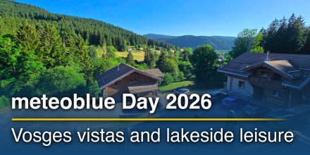
AD FREE

Remove ads for 9 € per year
- 3h
3-hourly view
3h 1h
Icon
Overcast with light snow
Mostly cloudy
Partly cloudy
Partly cloudy
Partly cloudy
Clear with few low clouds
Partly cloudy
Partly cloudy
°F
32°
31°
32°
34°
36°
34°
32°
31°
°F
21°
21°
22°
24°
25°
24°
25°
24°
NW
NW
NW
NNW
NW
NNW
N
NNW
mph
12-33
10-27
10-26
10-28
11-29
10-27
4-22
4-18
in
< 0.04
-
-
-
-
-
-
-
%
100%
80%
60%
45%
55%
60%
40%
25%
in

00:00 to 01:00:
100% chance of precipitation in the area.
0″ are predicted by our local models.

01:00 to 02:00:
95% chance of precipitation in the area.
0″ are predicted by our local models.

02:00 to 03:00:
85% chance of precipitation in the area.
0″ are predicted by our local models.

03:00 to 04:00:
80% chance of precipitation in the area.
0″ are predicted by our local models.

04:00 to 05:00:
70% chance of precipitation in the area.
0″ are predicted by our local models.

05:00 to 06:00:
65% chance of precipitation in the area.
0″ are predicted by our local models.

06:00 to 07:00:
60% chance of precipitation in the area.
0″ are predicted by our local models.

07:00 to 08:00:
55% chance of precipitation in the area.
0″ are predicted by our local models.

08:00 to 09:00:
50% chance of precipitation in the area.
0″ are predicted by our local models.

09:00 to 10:00:
45% chance of precipitation in the area.
0″ are predicted by our local models.

10:00 to 11:00:
40% chance of precipitation in the area.
0″ are predicted by our local models.

11:00 to 12:00:
40% chance of precipitation in the area.
0″ are predicted by our local models.

12:00 to 13:00:
50% chance of precipitation in the area.
0″ are predicted by our local models.

13:00 to 14:00:
50% chance of precipitation in the area.
0″ are predicted by our local models.

14:00 to 15:00:
55% chance of precipitation in the area.
0″ are predicted by our local models.

15:00 to 16:00:
60% chance of precipitation in the area.
0″ are predicted by our local models.

16:00 to 17:00:
55% chance of precipitation in the area.
0″ are predicted by our local models.

17:00 to 18:00:
50% chance of precipitation in the area.
0″ are predicted by our local models.

18:00 to 19:00:
40% chance of precipitation in the area.
0″ are predicted by our local models.

19:00 to 20:00:
35% chance of precipitation in the area.
0″ are predicted by our local models.

20:00 to 21:00:
25% chance of precipitation in the area.
0″ are predicted by our local models.

21:00 to 22:00:
25% chance of precipitation in the area.
0″ are predicted by our local models.

22:00 to 23:00:
25% chance of precipitation in the area.
0″ are predicted by our local models.

23:00 to 00:00:
5% chance of precipitation in the area.
0″ are predicted by our local models.

12.4 mi
Overcast with light snow
Mostly cloudy
Partly cloudy
Partly cloudy
Partly cloudy
Clear with few low clouds
Partly cloudy
Partly cloudy
32°
31°
32°
34°
36°
34°
32°
31°
21°
21°
22°
24°
25°
24°
25°
24°
NW
12-33
NW
10-27
NW
10-26
NNW
10-28
NW
11-29
NNW
10-27
N
4-22
NNW
4-18
< 0.04 in
100%
-
80%
-
60%
-
45%
-
55%
-
60%
-
40%
-
25%
The weather forecast has medium predictability. Compare different forecasts with MultiModel.

Weather report for Labaroche

Overnight into Thursday the weather is changing with a mix of clear and cloudy skies and a chance of snow. In the course of day no more snow is expected but it remains partly cloudy. The sun will not be visible. With 60% probability of precipitation we are at the upper end of a moderate chance. Temperature highs are likely to reach 36 °F. Overnight into Thursday expect a moderate breeze (12 to 18 mph). During the day a gentle breeze is expected (8 to 12 mph). From time to time gusts could reach up to 33 mph. Winds blowing from Northwest. The weather forecast for Labaroche for Thursday can be accurate in parts but deviations are expected. Check again for latest updates.

sun-icon
UV 2
06:19
18:53
Waxing gibbous moon (99°)
11:00
03:21

Pressure: 1016 hPa

Timezone: CET (UTC +01:00h)

Official severe weather warnings

Vigilance jaune orages
Moderate weather warning
Now
From Today 06:00 (1 hour ago)
Until Midnight (16 hours from now)
Moderate thunderstorm warning
Moderate weather warning
Now
From Today 06:00 (1 hour ago)
Until Midnight (16 hours from now)
Last update:
Language:
Vigilance jaune neige-verglas
Moderate weather warning
Upcoming
From Tomorrow 00:00 (16 hours from now)
Until Saturday 00:00 (1 day from now)
Moderate snow-ice warning
Moderate weather warning
Upcoming
From Tomorrow 00:00 (16 hours from now)
Until Saturday 00:00 (1 day from now)
Last update:
Language:

Radar and precipitation nowcast, France

Drizzle
Light
Moderate
Heavy
Very Heavy
Hail

The location marker is placed on Labaroche. This animation shows the precipitation radar for the selected time range, as well as a 2h forecast. Orange crosses indicate lightning. Data provided by nowcast.de (available in USA, Europe, Australia). Drizzle or light snow fall might be invisible for the radar. Precipitation intensity is colour coded, ranging from turquoise to red.

Hourly weather forecast for Labaroche

Our 5-day meteogram for Labaroche offers all weather information in 3 simple graphs: [More]
  • Temperature chart with weather pictograms. The yellow background indicates daylight.
  • Clouds in different altitudes: from few clouds (light grey) to overcast (dark grey). Dark blue bars show hourly precipitation and light blue showers. An asterisk indicates snow fall.
  • Forecasts for wind speeds are blue and for gusts are green. The arrowheads point in the same direction as the wind.

You can embed this meteogram into your own website. Customize it here.

Live satellite map, France

The location marker is placed on Labaroche. [More]

The real-time satellite image combines visible light during daytime with infrared radiation during nighttime. At night, the image is not dark as infrared radiation can detect temperature differences. Unfortunately, low clouds and fog are difficult to distinguish from ground temperatures and thus can be almost invisible during the night. Meteosat satellite images for Europe are updated in real-time every 5 minutes. GOES-16/GOES-17 (North & South America) and Himawari (Asia) images update every 10 minutes.

Precipitation is estimated from radar and satellites. Precipitation estimates from satellites are less accurate at night than during daytime.

© 2026 meteoblue, NOAA Satellites GOES-16 and EUMETSAT. Lightning data provided by nowcast.

Back to top
×
Hey there,
seems like you are using an ad blocker.

Advertising is essential to maintain our free website with unique detail and accuracy.

Please whitelist www.meteoblue.com on your ad blocker or consider buying one of our products:

Already have a subscription?
Then please login.