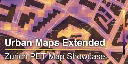
meteoblue Ad-free 9 €
Icon
Heavy rain, thunderstorms likely
Rain, thunderstorms likely
Light rain, thunderstorms likely
Mixed with cirrus with some thunderstorm clouds possible
Light rain, thunderstorms likely
Temperature (°F)
81°
81°
81°
81°
83°
83°
86°
86°
86°
86°
84°
84°
82°
82°
82°
82°
Temperature felt (°F)
92°
92°
95°
99°
98°
95°
93°
93°
Wind direction
SW
SW
WSW
W
W
SW
WSW
SW
Wind speed (mph)
SW
3-11
3-11
SW
3-13
3-13
WSW
3-14
3-14
W
4-18
4-18
W
4-14
4-14
SW
4-11
4-11
WSW
3-10
3-10
SW
3-10
3-10
Precipitation (in/3h)
0.61 in
60%
0.61
1.85 in
60%
1.85
0.31 in
85%
0.31
< 0.04 in
85%
< 0.04
0.06 in
85%
0.06
< 0.04 in
95%
< 0.04
-
85%
-
< 0.04 in
50%
< 0.04
Precipitation probability
60%
60%
85%
85%
85%
95%
85%
50%
Precipitation hourly

00:00 to 01:00:
60% chance of precipitation in the area.
0.1″ are predicted by our local models.

01:00 to 02:00:
60% chance of precipitation in the area.
0.16″ are predicted by our local models.

02:00 to 03:00:
60% chance of precipitation in the area.
0.35″ are predicted by our local models.

03:00 to 04:00:
60% chance of precipitation in the area.
0.59″ are predicted by our local models.

04:00 to 05:00:
60% chance of precipitation in the area.
0.7″ are predicted by our local models.

05:00 to 06:00:
60% chance of precipitation in the area.
0.55″ are predicted by our local models.

06:00 to 07:00:
60% chance of precipitation in the area.
0.26″ are predicted by our local models.

07:00 to 08:00:
75% chance of precipitation in the area.
0.04″ are predicted by our local models.

08:00 to 09:00:
85% chance of precipitation in the area.
0″ are predicted by our local models.

09:00 to 10:00:
85% chance of precipitation in the area.
0″ are predicted by our local models.

10:00 to 11:00:
75% chance of precipitation in the area.
0.01″ are predicted by our local models.

11:00 to 12:00:
75% chance of precipitation in the area.
0.01″ are predicted by our local models.

12:00 to 13:00:
85% chance of precipitation in the area.
0.02″ are predicted by our local models.

13:00 to 14:00:
75% chance of precipitation in the area.
0.02″ are predicted by our local models.

14:00 to 15:00:
85% chance of precipitation in the area.
0.02″ are predicted by our local models.

15:00 to 16:00:
85% chance of precipitation in the area.
0.01″ are predicted by our local models.

16:00 to 17:00:
85% chance of precipitation in the area.
0″ are predicted by our local models.

17:00 to 18:00:
95% chance of precipitation in the area.
0″ are predicted by our local models.

18:00 to 19:00:
85% chance of precipitation in the area.
0″ are predicted by our local models.

19:00 to 20:00:
75% chance of precipitation in the area.
0″ are predicted by our local models.

20:00 to 21:00:
50% chance of precipitation in the area.
0″ are predicted by our local models.

21:00 to 22:00:
50% chance of precipitation in the area.
0″ are predicted by our local models.

22:00 to 23:00:
40% chance of precipitation in the area.
0″ are predicted by our local models.

23:00 to 00:00:
50% chance of precipitation in the area.
0.02″ are predicted by our local models.

rainSPOT Precipitation distribution within 20 km
1h view
Hourly view
The weather forecast has medium predictability. Compare different forecasts with MultiModel.

Weather report for Shenzhen

The whole day there is a chance of thunderstorms and local showers. Heavy precipitation of >0. 8" is forecast for Tuesday. The sun will not be visible. A very high chance of Precipitation near 90% is forecast. Temperatures peaking at 86 °F. With UV-Index rising to 8, sun protection is strongly recommended. During the night and in the morning light air is noticeable (1 to 4 mph). For the afternoon blows a light breeze (4 to 8 mph). Gusts to 18 mph are possible. Winds blowing overnight from Southwest and by day from West. The weather forecast for Shenzhen for Tuesday can be accurate in parts but deviations are expected. Check again for latest updates.

sun-icon
UV 8
05:52
19:07
Waxing crescent moon (57°)
09:47
22:01

Pressure: 996 hPa

Timezone: CST (UTC +08:00h)

Official severe weather warnings

Rainstorm yellow warning [Level III/heavy] issued by Shenzhen Meteorological Observatory
Moderate
Now
From Monday 19:53 (9 hours ago)
Until further notice
深圳市气象台发布暴雨黄色预警[III级/较重]
Moderate
Now
From Monday 19:53 (9 hours ago)
Until further notice
Last update:
Language:
Thunderstorm Warning issued at 1:20 a.m. on 29 Jul 2025 will remain in force until 5:30 a.m. today.
Severe
Now
From Today 03:50 (1 hour ago)
Until Today 05:30 (27 minutes from now)
天文台在7月29日上午1時20分發出雷暴警告,有效時間至今日上午5時30分。
Severe
Now
From Today 03:50 (1 hour ago)
Until Today 05:30 (27 minutes from now)
Last update:
Language:

Weather radar, China

Drizzle
Light
Moderate
Heavy
Very Heavy
Hail

The location marker is placed on Shenzhen. Orange crosses indicate lightning. Data provided by nowcast.de (available in USA, Europe, Australia). Drizzle or light snow fall might be invisible for the radar. Precipitation intensity is colour coded, ranging from turquoise to red.

Hourly weather forecast for Shenzhen

Our 5-day meteogram for Shenzhen offers all weather information in 3 simple graphs: [More]
  • Temperature chart with weather pictograms. The yellow background indicates daylight.
  • Clouds in different altitudes: from few clouds (light grey) to overcast (dark grey). Dark blue bars show hourly precipitation and light blue showers. An asterisk indicates snow fall.
  • Forecasts for wind speeds are blue and for gusts are green. The arrowheads point in the same direction as the wind.

Live satellite map, China

The location marker is placed on Shenzhen. [More]

The real-time satellite image combines visible light during daytime with infrared radiation during nighttime. At night, the image is not dark as infrared radiation can detect temperature differences. Unfortunately, low clouds and fog are difficult to distinguish from ground temperatures and thus can be almost invisible during the night. Meteosat satellite images for Europe are updated in real-time every 5 minutes. GOES-16/GOES-17 (North & South America) and Himawari (Asia) images update every 10 minutes.

Precipitation is estimated from radar and satellites. Precipitation estimates from satellites are less accurate at night than during daytime.

© 2025 meteoblue, NOAA Satellites GOES-16 and EUMETSAT. Lightning data provided by nowcast.

Back to top
×
Hey there,
seems like you are using an ad blocker.

Advertising is essential to maintain our free website with unique detail and accuracy.

Please whitelist www.meteoblue.com on your ad blocker or consider buying one of our products:

Already have a subscription?
Then please login.