Join meteoblue at Meteorological Technology World Expo 2025
Meet meteoblue (and Windy) at Meteorological Technology World Expo 2025 and discover the latest weather and climate solutions, complemented by coffee and delicious Swiss chocolate!


Meet meteoblue (and Windy) at Meteorological Technology World Expo 2025 and discover the latest weather and climate solutions, complemented by coffee and delicious Swiss chocolate!

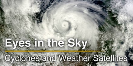
Satellites have transformed how we monitor our planet, especially when it comes to extreme weather. From hurricanes and typhoons to floods and wildfires, modern weather satellites can track storm evolution in real time and help assess damage after a disaster has passed.
|
|
|||||||||
|---|---|---|---|---|---|---|---|---|---|
|
Icon
|

|

|

|

|

|

|

|

|
|
|
Temperature (°F)
|
|||||||||
|
Temperature felt (°F)
|
64° |
62° |
72° |
79° |
75° |
73° |
72° |
66° |
|
|
Wind direction
|
S |
SSE |
SSE |
WSW |
NW |
NNW |
ESE |
NNW |
|
|
Wind speed (mph)
|
S
2-7
2-7
|
SSE
3-6
3-6
|
SSE
3-7
3-7
|
WSW
6-15
6-15
|
NW
10-16
10-16
|
NNW
6-14
6-14
|
ESE
1-5
1-5
|
NNW
3-9
3-9
|
|
|
Desert dust concentration
|
|||||||||
|
Precipitation (in/3h)
|
-
0%
-
|
-
0%
-
|
-
0%
-
|
-
0%
-
|
-
0%
-
|
-
0%
-
|
-
0%
-
|
-
0%
-
|
|
|
Precipitation probability
|
0%
|
0%
|
0%
|
0%
|
0%
|
0%
|
0%
|
0%
|
|
|
Precipitation hourly
|
|||||||||
|
Precipitation hourly
|
No precipitation expected |
||||||||
|
rainSPOT
Precipitation distribution within 20 km
|
|
||||||||
Overnight into Tuesday clear skies prevail, but in the morning a few clouds are expected. In the afternoon it is mostly cloudy. It is a sunny day. Temperatures peaking at 85 °F. With UV-Index rising to 9, sun protection is strongly recommended. Overnight into Tuesday light air is noticeable (1 to 4 mph). Early in the day blows a light breeze (4 to 8 mph). In the afternoon a gentle breeze is expected (8 to 12 mph). Winds blowing at night and in the morning from South and during the afternoon from Northwest. The weather forecast for Toufrek for Tuesday is expected to be very accurate.
Pressure: 1014 hPa
Timezone: CET (UTC +01:00h)
The real-time satellite image combines visible light during daytime with infrared radiation during nighttime. At night, the image is not dark as infrared radiation can detect temperature differences. Unfortunately, low clouds and fog are difficult to distinguish from ground temperatures and thus can be almost invisible during the night. Meteosat satellite images for Europe are updated in real-time every 5 minutes. GOES-16/GOES-17 (North & South America) and Himawari (Asia) images update every 10 minutes.
Precipitation is estimated from radar and satellites. Precipitation estimates from satellites are less accurate at night than during daytime.
© 2025 meteoblue, NOAA Satellites GOES-16 and EUMETSAT. Lightning data provided by nowcast.
The location marker is placed on Toufrek. Orange crosses indicate lightning. Data provided by nowcast.de (available in USA, Europe, Australia). Drizzle or light snow fall might be invisible for the radar. Precipitation intensity is colour coded, ranging from turquoise to red.

Meet meteoblue (and Windy) at Meteorological Technology World Expo 2025 and discover the latest weather and climate solutions, complemented by coffee and delicious Swiss chocolate!

Satellites have transformed how we monitor our planet, especially when it comes to extreme weather. From hurricanes and typhoons to floods and wildfires, modern weather satellites can track storm evolution in real time and help assess damage after a disaster has passed.
 Zerzoua
 Tozouni
 Gara Tirhsi
 Ti-n- Teres
 Ti-n-Tarha
 Ti-n-Hammane
 Ti-n-Hammane
 Djebel Timrhaneïdi
 Gara Timentate
 Timbelrhene
 Tifinanine
 Terzekkouline
Advertising is essential to maintain our free website with unique detail and accuracy.
Please whitelist www.meteoblue.com on your ad blocker or consider buying one of our products:
Already have a subscription?
Then please login.