
Over recent weeks, temperatures exceeding 40 degrees Celsius have been recorded in parts of Laos, Myanmar, and Thailand. Last Friday (2023-04-21), Bangkok residents were advised to stay indoors due to heat stress, while the northern province of Tak Prabang documented temperatures above 40°C. Thailand, along with other Southeast Asian countries, is grappling with the ongoing heatwave. Our temperature map indicates that extreme heat will persist in the coming days.
To analyse typical weather conditions for a specific location, we recommend using our climate diagrams. The screenshots display the average temperatures and precipitation sums for Luang Prabang and T throughout the year. These diagrams are derived from 30 years of hourly weather weather simulations and are accessible for every place on Earth.
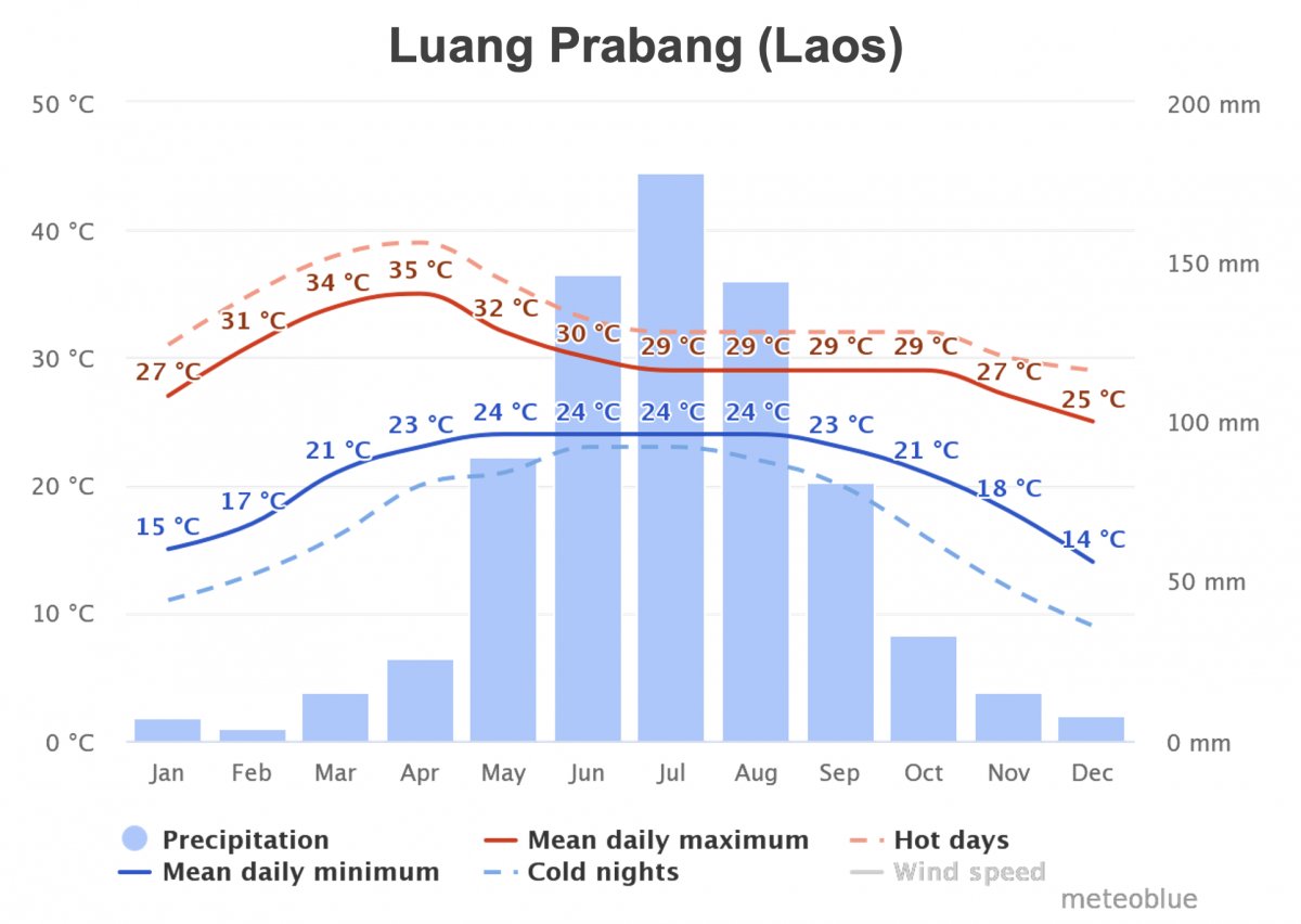

In both locations, the highest annual temperatures occur in April, just before a significant drop in temperatures accompanied by an increase in precipitation, ushering in the rainy season. This year, temperatures have remained elevated for an extended period, as evidenced by our weather archive, like the sample for Tak Prabang, while precipitation has been virtually nonexistent.
Our anomaly weather maps enable comparison of current weather conditions to a 40-year reference period. As depicted below, a positive temperature anomaly (left image) indicates excessive heat across much of Southeast Asia. Additionally, a negative precipitation anomaly (right image) reveals decreased rainfall compared to historical levels for the respective areas.


In addition to the prolonged heatwave in Southeast Asia, which has already claimed several lives, the burning season also contributes to poor air quality. Between December and April, farmers in the region engage in crop residue burning. This slash-and-burn practice leads to substantial air pollution and increased particulate matter (PM) emissions, causing respiratory diseases, skin irritations, and eye infections.
Chiang Mai (Thailand) is currently ranked as the most polluted city worldwide, according to multiple sources. Millions are affected by biomass burning, which generates smog (smoke and fog). The resulting ash clouds contain pollutants such as black carbon, PM2.5 (particles with a diameter of 2.5 micrometres), and PM10 (10 micrometres). Inhalation of these particles can cause lung damage and weaken the immune system.
The Aerosol Optical Depth (AOD) map for 2023-04-26 illustrates the total light extinction in the vertical atmosphere due to aerosols. A higher optical depth value indicates a greater aerosol concentration. These aerosols originate from various sources, such as wildfires, biomass burning, desert dust, and anthropogenic air pollution. In essence, this map portrays the overall pollution caused by aerosols. These aerosols are emitted into the atmosphere by various natural and anthropogenic sources. For example, forest fires, desert dust and sea spray are natural aerosol sources, whereas biomass burning is an anthropogenic aerosol source. In principle, therefore, the AOD map shows all air pollution caused by aerosols. Raindrops are not counted as aerosols by definition, they are called hydrometeors.
It is hoped that the imminent rainy season will end the heatwave and cleanse the atmosphere of pollutant aerosols. We are confident that the aforementioned tools will prove valuable in analysing the weather situation in this region and elsewhere.

