


Summer arrived in parts of Europe. Particularly striking is the rise in temperature on the west coast of France and the north coast of Spain (Bay of Biscay) over the course of the next week. By midweek, 30°C are expected in Bilbao, and 31°C in Bordeaux. Our extreme forecast map (second screenshot) predicts warmer-than-average temperatures for the Bay of Biscay in the coming days. The stronger the colours, the greater the deviation of the forecast values compared to the seasonally normal temperatures. Reddish colours represent warmer-than-average regions, while bluish colours represent colder-than-average regions. The average temperatures are based on data from the past 30 years.
Urban areas, particularly cities, often experience significantly higher temperatures than their surrounding rural areas due to a phenomenon known as the Urban Heat Island (UHI) effect. This effect is primarily caused by urban structures, tightly packed buildings, and other urban factors, all of which contribute to cities heating up more rapidly and intensely than rural areas. Green spaces such as parks, outdoor swimming pools, and other urban recreational areas provide a cooling counter-effect to this urban heat. They serve as refreshing spots within the cityscape, offering a respite from the heat. meteoblue has now introduced heat maps for selected cities across the globe. These maps enable users to locate areas within the city that have the most comfortable climate. Moreover, they play a vital role in urban planning, helping to identify local heat islands and plan appropriate cooling strategies.
These heat maps are generated using data derived from satellite images, measurements, and air temperature models. They provide a detailed view of the temperature distribution across cities with a resolution of 10 by 10 metres.
We have analysed the heat map for Bilbao (Friday, 2 June 2023):
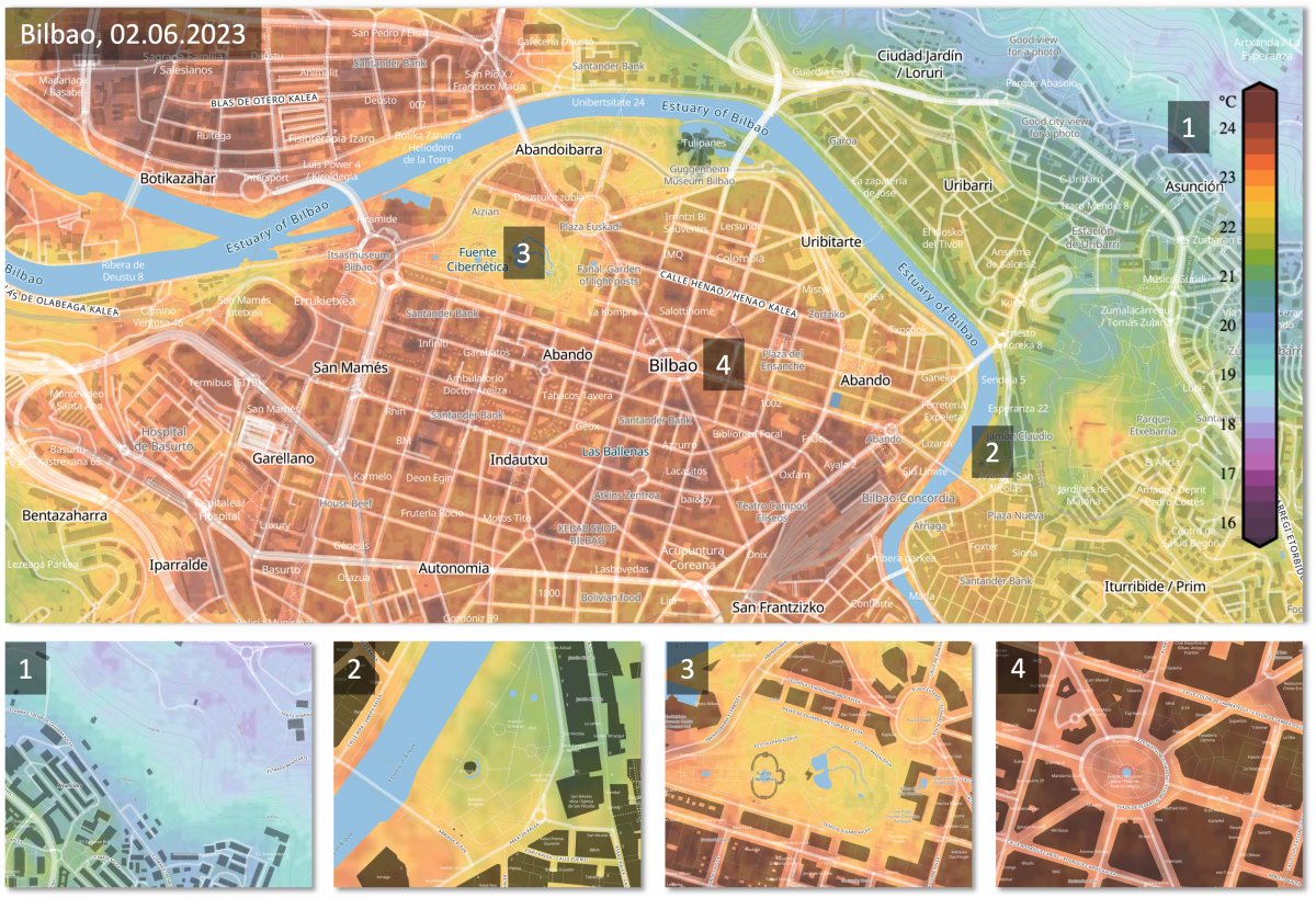
The figure clearly shows the UHI effect. Urban areas with a high degree of sealing and dense development (4) have significantly higher temperatures, as urban parks (3) and the less sealed and less densely developed surrounding areas adjacent to the city centre (2). In this case, temperatures become significantly colder outside the city centre. The orographic elevations (1) lead to significant cooling due to vegetation and the altitude effect.
Especially on hot days or during heat waves, the maps enable the identification of cooler locations. Residents of Bilbao can now better find the cooler places or hours of the day with the help of the heat map.
