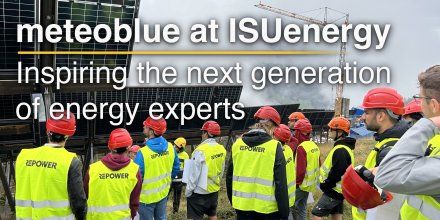
meteoblue Ad-free 9 €
Icon
Clear, cloudless sky
Clear with few low clouds
Clear, cloudless sky
Clear with few low clouds
Partly cloudy
Temperature (°F)
78°
78°
77°
77°
78°
78°
80°
80°
79°
79°
77°
77°
75°
75°
74°
74°
Temperature felt (°F)
73°
73°
73°
77°
78°
73°
71°
69°
Wind direction
NNW
NNW
NNW
NNW
NNW
NNW
NNW
NNW
Wind speed (mph)
NNW
13-27
13-27
NNW
13-26
13-26
NNW
14-25
14-25
NNW
15-24
15-24
NNW
16-24
16-24
NNW
16-25
16-25
NNW
15-25
15-25
NNW
14-22
14-22
Precipitation (in/3h)
-
0%
-
-
0%
-
-
0%
-
-
0%
-
-
0%
-
-
0%
-
-
0%
-
-
0%
-
Precipitation probability
0%
0%
0%
0%
0%
0%
0%
0%
Precipitation hourly

00:00 to 01:00:
0% chance of precipitation in the area.
0″ are predicted by our local models.

01:00 to 02:00:
0% chance of precipitation in the area.
0″ are predicted by our local models.

02:00 to 03:00:
0% chance of precipitation in the area.
0″ are predicted by our local models.

03:00 to 04:00:
0% chance of precipitation in the area.
0″ are predicted by our local models.

04:00 to 05:00:
0% chance of precipitation in the area.
0″ are predicted by our local models.

05:00 to 06:00:
0% chance of precipitation in the area.
0″ are predicted by our local models.

06:00 to 07:00:
0% chance of precipitation in the area.
0″ are predicted by our local models.

07:00 to 08:00:
0% chance of precipitation in the area.
0″ are predicted by our local models.

08:00 to 09:00:
0% chance of precipitation in the area.
0″ are predicted by our local models.

09:00 to 10:00:
0% chance of precipitation in the area.
0″ are predicted by our local models.

10:00 to 11:00:
0% chance of precipitation in the area.
0″ are predicted by our local models.

11:00 to 12:00:
0% chance of precipitation in the area.
0″ are predicted by our local models.

12:00 to 13:00:
0% chance of precipitation in the area.
0″ are predicted by our local models.

13:00 to 14:00:
0% chance of precipitation in the area.
0″ are predicted by our local models.

14:00 to 15:00:
0% chance of precipitation in the area.
0″ are predicted by our local models.

15:00 to 16:00:
0% chance of precipitation in the area.
0″ are predicted by our local models.

16:00 to 17:00:
0% chance of precipitation in the area.
0″ are predicted by our local models.

17:00 to 18:00:
0% chance of precipitation in the area.
0″ are predicted by our local models.

18:00 to 19:00:
0% chance of precipitation in the area.
0″ are predicted by our local models.

19:00 to 20:00:
0% chance of precipitation in the area.
0″ are predicted by our local models.

20:00 to 21:00:
0% chance of precipitation in the area.
0″ are predicted by our local models.

21:00 to 22:00:
0% chance of precipitation in the area.
0″ are predicted by our local models.

22:00 to 23:00:
0% chance of precipitation in the area.
0″ are predicted by our local models.

23:00 to 00:00:
0% chance of precipitation in the area.
0″ are predicted by our local models.

Precipitation hourly

No precipitation expected

rainSPOT Precipitation distribution within 20 km
Sea/surf forecast
Significant wave height (m)
1.1
1.1
1.2
1.2
1.2
1.2
1.2
1.2
1.3
1.3
1.3
1.3
1.3
1.3
1.4
1.4
Significant wave direction in which the waves move
Water temperature (°F)
72°
72°
72°
72°
72°
72°
72°
72°
Sea/surf forecast
1h view
Hourly view
The weather forecast has very high predictability. Compare different forecasts with MultiModel.

Weather report for Las Palmas de Gran Canaria

Overnight into Friday clear skies prevail, but in the course of day a few clouds are expected. It is a sunny day. Temperature highs are likely to reach 80 °F. With a UV-Index as high as 10 make sure to properly protect your skin. On Friday expect a moderate breeze (12 to 18 mph). From time to time gusts could reach up to 27 mph. Winds blowing overnight from Northwest and by day from North. The weather forecast for Las Palmas de Gran Canaria for Friday is expected to be very accurate.

sun-icon
UV 10
07:15
21:00
Last quarter moon (276°)
01:20
14:49

Pressure: 1017 hPa

Timezone: WEST (UTC +01:00h)

Official severe weather warnings

Aviso de temperaturas máximas de nivel naranja. Este, sur y oeste de Gran Canaria
Severe
Now
From Today 09:00 (6 hours ago)
Until Today 20:59 (5 hours from now)
Severe high-temperature warning. Este, sur y oeste de Gran Canaria
Severe
Now
From Today 09:00 (6 hours ago)
Until Today 20:59 (5 hours from now)
Last update:
Language:
Aviso de costeros de nivel amarillo. Costa - Este, sur y oeste de Gran Canaria
Moderate
Now
From Today 05:00 (10 hours ago)
Until Today 22:59 (7 hours from now)
Moderate coastalevent warning. Costa - Este, sur y oeste de Gran Canaria
Moderate
Now
From Today 05:00 (10 hours ago)
Until Today 22:59 (7 hours from now)
Last update:
Language:

Hourly weather forecast for Las Palmas de Gran Canaria

Our 5-day meteogram for Las Palmas de Gran Canaria offers all weather information in 3 simple graphs: [More]
  • Temperature chart with weather pictograms. The yellow background indicates daylight.
  • Clouds in different altitudes: from few clouds (light grey) to overcast (dark grey). Dark blue bars show hourly precipitation and light blue showers. An asterisk indicates snow fall.
  • Forecasts for wind speeds are blue and for gusts are green. The arrowheads point in the same direction as the wind.

Live satellite map, Spain

The location marker is placed on Las Palmas de Gran Canaria. [More]

The real-time satellite image combines visible light during daytime with infrared radiation during nighttime. At night, the image is not dark as infrared radiation can detect temperature differences. Unfortunately, low clouds and fog are difficult to distinguish from ground temperatures and thus can be almost invisible during the night. Meteosat satellite images for Europe are updated in real-time every 5 minutes. GOES-16/GOES-17 (North & South America) and Himawari (Asia) images update every 10 minutes.

Precipitation is estimated from radar and satellites. Precipitation estimates from satellites are less accurate at night than during daytime.

© 2025 meteoblue, NOAA Satellites GOES-16 and EUMETSAT. Lightning data provided by nowcast.

Radar and precipitation nowcast, Spain

Drizzle
Light
Moderate
Heavy
Very Heavy
Hail

The location marker is placed on Las Palmas de Gran Canaria. This animation shows the precipitation radar for the selected time range, as well as a 2h forecast. Orange crosses indicate lightning. Data provided by nowcast.de (available in USA, Europe, Australia). Drizzle or light snow fall might be invisible for the radar. Precipitation intensity is colour coded, ranging from turquoise to red.

Back to top
×
Hey there,
seems like you are using an ad blocker.

Advertising is essential to maintain our free website with unique detail and accuracy.

Please whitelist www.meteoblue.com on your ad blocker or consider buying one of our products:

Already have a subscription?
Then please login.