In all 30 locations, there is a strong decline in
precipitation from April to July in 2018, with more than twice as much precipitation in April compared with July. This trend can be well observed in Northwest Europe; In Brussels (BEL), the monthly precipitation was above the 30-year mean, while May and June were dryer than average and July was the driest ever since 1985. In Berlin (GER), although it seems like in March it should have rained enough, only April had more rainfall than normal. Overall, there was a reduction of precipitation of almost 1/3 during the 4 months compared to average.
Stockholm (SWE) was by far the driest of the 30 analyzed places. A total of 76 mm of precipitation fell during the four-month period, according to our NEMS12 Model. The average amount of precipitation during this time-period is 165 mm (NEMSGLOBAL), which is more than twice the amount of 2018. This 4-month period in Stockholm is the driest in the last 35 years.
The graph shows the 2 years with the most and least precipitation since 1985, the amount of rainfall per month on average, and for 2018.
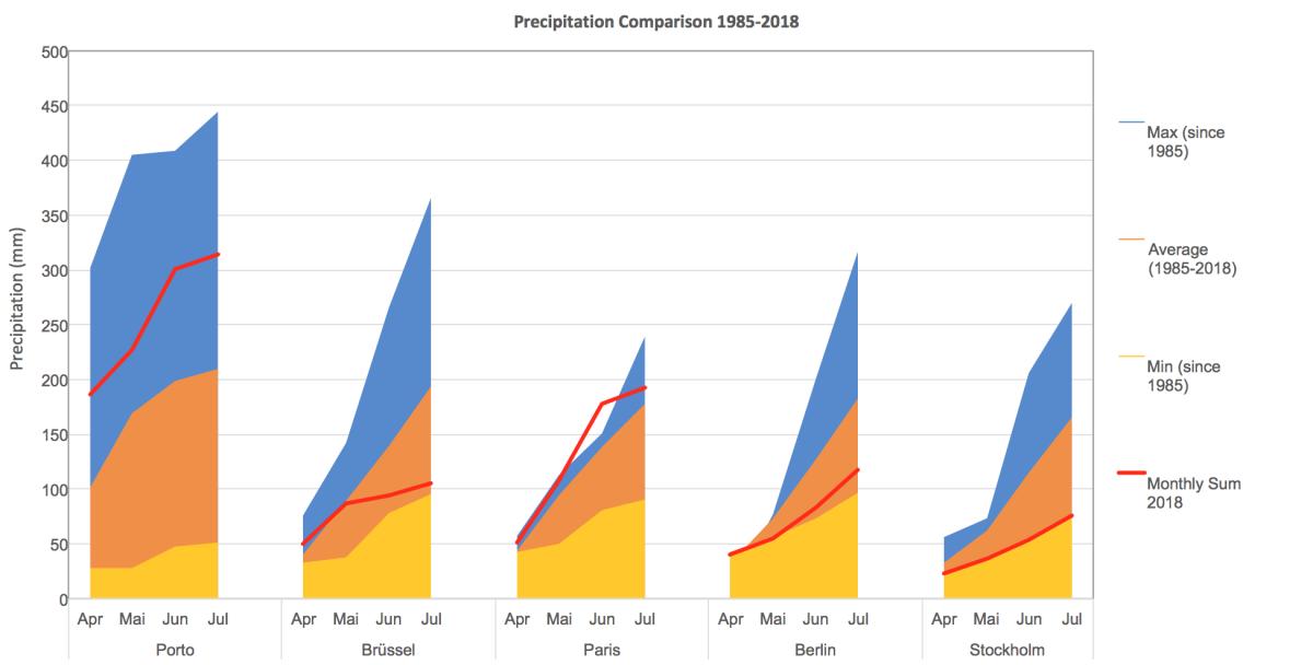
This analysis also showed, that places at the coast (e.g. Marseille, Nantes, FR; Lisbon or Porto, PT) or at least somewhat close to the sea (Paris FR) were more likely to have more precipitation than the average, while places located more centrally in the continent (e.g. Basel CH; Dortmund DE; Prague CZ; Vienna AT) had more months, that were drier than usual. The Southwest was more moist than usual, e.g. Porto (PT) with almost 450 mm of precipitation during the four-month period was the rainiest place of the 30: there, more than half the rain fell in April, while June and July also had amounts that were above the average rainfall.

For the current week, we offer a special 50% discount for all history+ purchases, so you can make your comparisons for your own location(s) with our history+ interface. Try it out and enter the coupon code for your purchase: history+20180805heat . We are available for questions.
