News

meteoblue Spring Day 2026
Bringing the team together for fun, exchange and valuable discussions.
Read on
Bringing the team together for fun, exchange and valuable discussions.
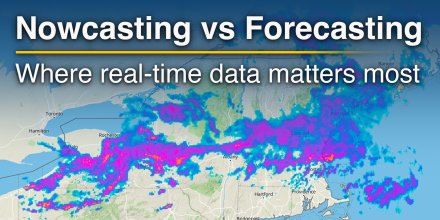
Short-term weather decisions often depend less on what might happen tomorrow and more on what is already unfolding now.
|
|
|
|
|
|
|
|
||
|
Icon
|

|

|

|

|

|

|
|

|
|
°F
|
73°
|
80°
|
84°
|
81°
|
75°
|
71°
|
69°
|
68°
|
|
°F
|
72°
|
77°
|
79°
|
76°
|
73°
|
72°
|
70°
|
69°
|
|
|
S |
SW |
SW |
SW |
SW |
WSW |
N |
ENE |
|
mph
|
7-15
|
10-24
|
11-26
|
10-26
|
5-18
|
2-8
|
1-5
|
1-2
|
|
μg/m³
|
Dust Levels Very High
Current concentration:
167 μg/m³.
|
Dust Levels Very High
Current concentration:
161 μg/m³.
|
Dust Levels Very High
Current concentration:
165 μg/m³.
|
Dust Levels Very High
Current concentration:
253 μg/m³.
|
Dust Levels Very High
Current concentration:
205 μg/m³.
|
Dust Levels Very High
Current concentration:
271 μg/m³.
|
Dust Levels Extremely High
Current concentration:
482 μg/m³.
|
Dust Levels Extremely High
Current concentration:
552 μg/m³.
|
|
in
|
-
|
-
|
0.06
|
-
|
-
|
-
|
-
|
-
|
|
%
|
10%
|
30%
|
40%
|
30%
|
20%
|
10%
|
0%
|
0%
|
|
in
|
||||||||
|
12.4 mi
|
On Friday it is mostly cloudy. The sun will not be visible. Temperatures as high as 84 °F are foreseen. With a UV-Index as high as 7 make sure to properly protect your skin. During the night and in the first hours of the day expect a moderate breeze (12 to 18 mph). For the afternoon a gentle breeze is expected (8 to 12 mph). From time to time gusts could reach up to 26 mph. Winds blowing from Southwest. The weather forecast for 26. 72°N 72. 9°E for Friday can be accurate in parts but deviations are expected. Check again for latest updates.

Pressure: 1009 hPa
Timezone: UTC
On Friday it is mostly cloudy. The sun will not be visible. Temperatures as high as 84 °F are foreseen. With a UV-Index as high as 7 make sure to properly protect your skin. During the night and in the first hours of the day expect a moderate breeze (12 to 18 mph). For the afternoon a gentle breeze is expected (8 to 12 mph). From time to time gusts could reach up to 26 mph. Winds blowing from Southwest. The weather forecast for 26. 72°N 72. 9°E for Friday can be accurate in parts but deviations are expected. Check again for latest updates.
Pressure: 1009 hPa
Timezone: UTC
By comparing today's temperatures to 40 years of historical data we can see whether today's forecast is unusually warm (red areas) or cold (blue areas). Coloured dots show observed actual temperatures from professional and private weather stations.
The location marker is placed on 26.72°N 72.9°E. Orange crosses indicate lightning. Data provided by nowcast.de (available in USA, Europe, Australia). Drizzle or light snow fall might be invisible for the radar. Precipitation intensity is colour coded, ranging from turquoise to red.
You can embed this meteogram into your own website. Customize it here.
The real-time satellite image combines visible light during daytime with infrared radiation during nighttime. At night, the image is not dark as infrared radiation can detect temperature differences. Unfortunately, low clouds and fog are difficult to distinguish from ground temperatures and thus can be almost invisible during the night. Meteosat satellite images for Europe are updated in real-time every 5 minutes. GOES-16/GOES-17 (North & South America) and Himawari (Asia) images update every 10 minutes.
Precipitation is estimated from radar and satellites. Precipitation estimates from satellites are less accurate at night than during daytime.
© 2026 meteoblue, NOAA Satellites GOES-16 and EUMETSAT. Lightning data provided by nowcast.
Bringing the team together for fun, exchange and valuable discussions.
Short-term weather decisions often depend less on what might happen tomorrow and more on what is already unfolding now.
Advertising is essential to maintain our free website with unique detail and accuracy.
Please whitelist www.meteoblue.com on your ad blocker or consider buying one of our products:
Already have a subscription?
Then please login.


 Jodhpur


